IMAGES TAKEN NEAR TO
Oyster Way, MANSFIELD, NG20 0FG
Introduction
This page details the photographs taken nearby to Oyster Way, NG20 0FG by members of the Geograph project.
The Geograph project started in 2005 with the aim of publishing, organising and preserving representative images for every square kilometre of Great Britain, Ireland and the Isle of Man.

There are currently over 7.5m images from over14,400 individuals and you can help contribute to the project by visiting https://www.geograph.org.uk
Image Map
Images are licensed for reuse under creativecommons.org/licenses/by-sa/2.0
Notes
- Clicking on the map will re-center to the selected point.
- The higher the marker number, the further away the image location is from the centre of the postcode.
Image Listing (21 Images Found)
Images are licensed for reuse under creativecommons.org/licenses/by-sa/2.0
Image
Details
Distance
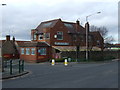
1
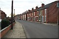
Terraced houses ready for demolition
Much of the 'old part' of Warsop (off Wood Street) is undergoing big changes. This row of terraces (built around 1890-1900) will soon be demolished to make way for more modern housing.
Image: © Sally Holmes
Taken: 11 Feb 2006
0.12 miles
3
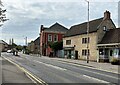
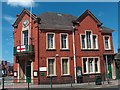
Church Street in Market Warsop
The Town Hall can also be seen here in the centre of picture
Image: © Jonathan Clitheroe
Taken: 19 Apr 2022
0.22 miles
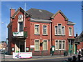
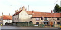
6
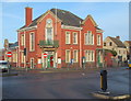
Church Street, Market Warsop, Notts.
The Town Hall is seen here at the junction of Church Street and Wood Street (with the No Entry signs). A Police Contact Point can now to be found here replacing the Police Station that functioned in High Street until October 2010. A local Veterinary Practice now operates from the former police station.
Image: © David Hallam-Jones
Taken: 23 Jan 2016
0.22 miles
7
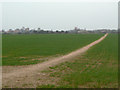
'Warsop FP3' footpath
Clearly a well beaten path paralleling the River Meden towards Warsop mill.
Image: © Alan Murray-Rust
Taken: 27 Mar 2011
0.23 miles
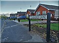
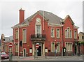
10
Church Street, Market Warsop, Notts.
A couple of older residential properties opposite the Town Hall. The one on the right may be a Grade II-listed, early C18th house and office.
Image: © David Hallam-Jones
Taken: 23 Jan 2016
0.23 miles