IMAGES TAKEN NEAR TO
Warsop, MANSFIELD, NG20 0EU
Introduction
This page details the photographs taken nearby to NG20 0EU by members of the Geograph project.
The Geograph project started in 2005 with the aim of publishing, organising and preserving representative images for every square kilometre of Great Britain, Ireland and the Isle of Man.

There are currently over 7.5m images from over14,400 individuals and you can help contribute to the project by visiting https://www.geograph.org.uk
Image Map
Images are licensed for reuse under creativecommons.org/licenses/by-sa/2.0
Notes
- Clicking on the map will re-center to the selected point.
- The higher the marker number, the further away the image location is from the centre of the postcode.
Image Listing (32 Images Found)
Images are licensed for reuse under creativecommons.org/licenses/by-sa/2.0
Image
Details
Distance
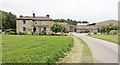
1

Sewage pumping station, Netherfield Lane, Meden Vale
Image: © Tim Heaton
Taken: 14 Feb 2009
0.06 miles
2
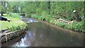
Are they trout in there?
Lots of fish in the River Meden at Meden Vale
Image: © Chris Morgan
Taken: 31 May 2016
0.06 miles
5
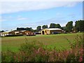
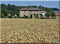
Assarts Farm (Meden Vale)
Looking to Assarts Farm from the railway embankment to the east.
Image: © David Simpson
Taken: 28 Aug 2008
0.08 miles
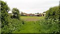
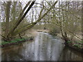
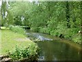
9

Bottoms local nature reserve
An area of woodland around the River Meden.
Image: © Jonathan Thacker
Taken: 1 Jan 2022
0.09 miles