IMAGES TAKEN NEAR TO
Forest Road, MANSFIELD, NG20 0EP
Introduction
This page details the photographs taken nearby to Forest Road, NG20 0EP by members of the Geograph project.
The Geograph project started in 2005 with the aim of publishing, organising and preserving representative images for every square kilometre of Great Britain, Ireland and the Isle of Man.

There are currently over 7.5m images from over14,400 individuals and you can help contribute to the project by visiting https://www.geograph.org.uk
Image Map
Images are licensed for reuse under creativecommons.org/licenses/by-sa/2.0
Notes
- Clicking on the map will re-center to the selected point.
- The higher the marker number, the further away the image location is from the centre of the postcode.
Image Listing (11 Images Found)
Images are licensed for reuse under creativecommons.org/licenses/by-sa/2.0
Image
Details
Distance
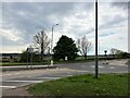
1
Bradmer Windmill in Market Warsop
Grade II Listed windmill situated to the south east of the town and built circa 1825. A local businessman - Samuel Fell Wilson, was shot and killed here in 1930.
Image: © Jonathan Clitheroe
Taken: 19 Apr 2022
0.11 miles
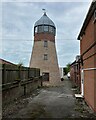
2
Warsop Windmill
A former tower mill now adapted https://historicengland.org.uk/listing/the-list/list-entry/1074946?section=official-listing
Image: © Jonathan Thacker
Taken: 30 Jan 2022
0.12 miles
5
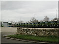
No-one goes out on a Sunday
Bowring Transport, Bradmer Hill.
Image: © Jonathan Thacker
Taken: 30 Jan 2022
0.16 miles
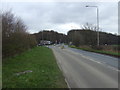
6
A bend in the A6075
Peafield Lane heading east towards Edwinstowe.
Image: © JThomas
Taken: 17 Mar 2014
0.17 miles
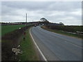
7
Peafield Lane (A6075)
Heading east towards Edwinstowe.
Image: © JThomas
Taken: 17 Mar 2014
0.19 miles
8
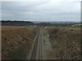
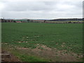
Railway heading north
Mineral line towards Worksop.
Image: © JThomas
Taken: 17 Mar 2014
0.21 miles
9
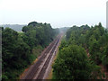
Railtrack passing under Peafield Lane
This image was taken from the bridge.
Image: © James Hill
Taken: 9 Jun 2007
0.22 miles