IMAGES TAKEN NEAR TO
Mansfield Road, MANSFIELD, NG20 0EA
Introduction
This page details the photographs taken nearby to Mansfield Road, NG20 0EA by members of the Geograph project.
The Geograph project started in 2005 with the aim of publishing, organising and preserving representative images for every square kilometre of Great Britain, Ireland and the Isle of Man.

There are currently over 7.5m images from over14,400 individuals and you can help contribute to the project by visiting https://www.geograph.org.uk
Image Map
Images are licensed for reuse under creativecommons.org/licenses/by-sa/2.0
Notes
- Clicking on the map will re-center to the selected point.
- The higher the marker number, the further away the image location is from the centre of the postcode.
Image Listing (8 Images Found)
Images are licensed for reuse under creativecommons.org/licenses/by-sa/2.0
Image
Details
Distance
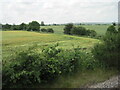
1
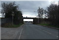
Railway bridge over Mansfield Road (A60)
Heading south west.
Image: © JThomas
Taken: 16 Mar 2014
0.03 miles
2
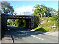
Railway Bridge over A60
Railway bridge over the A60 entry to Warsop.
Image: © James Hill
Taken: 29 Jun 2007
0.03 miles
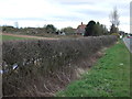

7
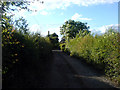
Askew Lane
Askew Lane, facing away from the entrance to the allotments.
Image: © James Hill
Taken: 29 Jun 2007
0.23 miles
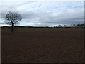
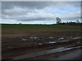
8
Fields near Market Warsop
This was from the former Lancashire Derbyshire and East Coast Railway line, which was open to freight between Shirebrook and High Marnham, when this image was taken.
Image: © Nigel Thompson
Taken: 14 Jun 2017
0.24 miles