IMAGES TAKEN NEAR TO
Sedgbrook Street, MANSFIELD, NG19 9QA
Introduction
This page details the photographs taken nearby to Sedgbrook Street, NG19 9QA by members of the Geograph project.
The Geograph project started in 2005 with the aim of publishing, organising and preserving representative images for every square kilometre of Great Britain, Ireland and the Isle of Man.

There are currently over 7.5m images from over14,400 individuals and you can help contribute to the project by visiting https://www.geograph.org.uk
Image Map
Images are licensed for reuse under creativecommons.org/licenses/by-sa/2.0
Notes
- Clicking on the map will re-center to the selected point.
- The higher the marker number, the further away the image location is from the centre of the postcode.
Image Listing (14 Images Found)
Images are licensed for reuse under creativecommons.org/licenses/by-sa/2.0
Image
Details
Distance
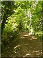
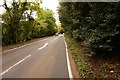
2
Maun Valley Trail, Mansfield
View from New Mill Lane, towards Old Mill Lane
Image: © Geoff Dunn
Taken: 3 Feb 2006
0.07 miles
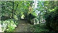
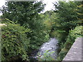
3
The Maun Valley Trail
Beside the River Maun on the line of an abandoned colliery railway
Image: © Graham Hogg
Taken: 3 Oct 2017
0.09 miles
5
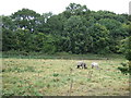
Grazing by the River Maun, Mansfield Woodhouse
Image: © JThomas
Taken: 7 Sep 2013
0.13 miles
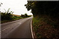
6
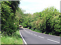
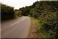
View down New Mill Lane
Approaching the hard left corner from this direction. Taken from a small layby.
Image: © James Hill
Taken: 23 May 2007
0.13 miles
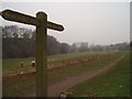
9
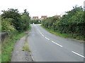
New Mill Lane heading west, Mansfield Woodhouse
Image: © JThomas
Taken: 7 Sep 2013
0.16 miles