IMAGES TAKEN NEAR TO
Manor House, MANSFIELD, NG19 9LU
Introduction
This page details the photographs taken nearby to Manor House, NG19 9LU by members of the Geograph project.
The Geograph project started in 2005 with the aim of publishing, organising and preserving representative images for every square kilometre of Great Britain, Ireland and the Isle of Man.

There are currently over 7.5m images from over14,400 individuals and you can help contribute to the project by visiting https://www.geograph.org.uk
Image Map
Images are licensed for reuse under creativecommons.org/licenses/by-sa/2.0
Notes
- Clicking on the map will re-center to the selected point.
- The higher the marker number, the further away the image location is from the centre of the postcode.
Image Listing (62 Images Found)
Images are licensed for reuse under creativecommons.org/licenses/by-sa/2.0
Image
Details
Distance
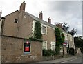
1
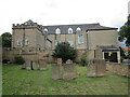
The Manor House, Mansfield Woodhouse
Has seventeenth century origins but much altered and extended. Now flats. https://historicengland.org.uk/listing/the-list/list-entry/1261279
Image: © Jonathan Thacker
Taken: 9 Sep 2021
0.01 miles
2
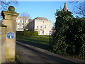
Mansfield Woodhouse - Manor House View
Image: © Alan Heardman
Taken: 10 Feb 2008
0.02 miles
3
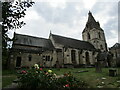
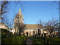
St. Edmund's church, Mansfield Woodhouse
Fourteenth century church much restored in the nineteenth century https://historicengland.org.uk/listing/the-list/list-entry/1251828
Image: © Jonathan Thacker
Taken: 9 Sep 2021
0.03 miles
4
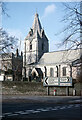
St Edmund's Church, Mansfield Woodhouse
Seen from the junction of Church Hill and Priory Road, St Edmund's dates from the early 14th century but it was extensively rebuilt between 1804 and 1810 and further heavily restored between 1847 and 1850. It is grade II* listed.
Image: © Stephen McKay
Taken: Unknown
0.03 miles
5
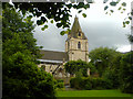
St. Edmund's Church
A view of St. Edmund's Church from the gardens next to it, just before a heavy shower of rain.
Image: © James Hill
Taken: 16 Jun 2007
0.03 miles
6
Mansfield Woodhouse - St. Edmund's Church
Image: © Alan Heardman
Taken: 10 Feb 2008
0.03 miles
7
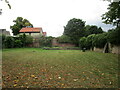
Public garden, Church Street, Mansfield Woodhouse
The boundary wall is listed https://historicengland.org.uk/listing/the-list/list-entry/1262571
Image: © Jonathan Thacker
Taken: 9 Sep 2021
0.04 miles
8
Mansfield Woodhouse - Priory Road View
Image: © Alan Heardman
Taken: 10 Feb 2008
0.05 miles
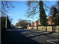
9
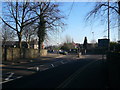
Mansfield Woodhouse - Approaching the mini-roundabout at the end of Priory Road
Image: © Alan Heardman
Taken: 10 Feb 2008
0.06 miles
10
12 Church Street, Mansfield Woodhouse
Early eighteenth century house https://historicengland.org.uk/listing/the-list/list-entry/1262572
Image: © Jonathan Thacker
Taken: 9 Sep 2021
0.07 miles