IMAGES TAKEN NEAR TO
Welbeck Road, MANSFIELD, NG19 9JY
Introduction
This page details the photographs taken nearby to Welbeck Road, NG19 9JY by members of the Geograph project.
The Geograph project started in 2005 with the aim of publishing, organising and preserving representative images for every square kilometre of Great Britain, Ireland and the Isle of Man.

There are currently over 7.5m images from over14,400 individuals and you can help contribute to the project by visiting https://www.geograph.org.uk
Image Map
Images are licensed for reuse under creativecommons.org/licenses/by-sa/2.0
Notes
- Clicking on the map will re-center to the selected point.
- The higher the marker number, the further away the image location is from the centre of the postcode.
Image Listing (49 Images Found)
Images are licensed for reuse under creativecommons.org/licenses/by-sa/2.0
Image
Details
Distance
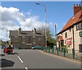
1
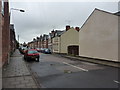
Poplar Street, Mansfield Woodhouse
Terraced houses, off Welbeck Road, the A6075.
Image: © Peter Barr
Taken: 16 Aug 2013
0.02 miles
2
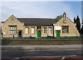
Mansfield Woodhouse - National School
On Welbeck Road.
Image: © Dave Bevis
Taken: 15 Apr 2011
0.05 miles
3
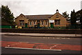
Cherubs Childcare Centre
Welbeck Road, Mansfield Woodhouse.
Image: © Ian S
Taken: 8 Oct 2016
0.05 miles
4
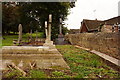
St Edmund's overflow graveyard
Welbeck Road, Mansfield Woodhouse.
Image: © Ian S
Taken: 8 Oct 2016
0.07 miles
5
3 wheels on my waggon
Waiting at the traffic lights on Welbeck Road, Mansfield Woodhouse near the Star Inn.
Image: © Steve Fareham
Taken: 8 Apr 2009
0.07 miles
6
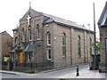
Mansfield Woodhouse - Mansfield Mission
On High Street.
Image: © Dave Bevis
Taken: 15 Apr 2011
0.08 miles
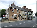
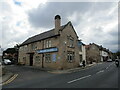
8
Mansfield Woodhouse - The Star
Please see Image for an alternative view.
Image: © Dave Bevis
Taken: 15 Apr 2011
0.09 miles
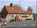
10
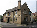
The Greyhound, Mansfield Woodhouse
Image: © Jonathan Thacker
Taken: 9 Sep 2021
0.10 miles