IMAGES TAKEN NEAR TO
Leeming Lane South, MANSFIELD, NG19 9AY
Introduction
This page details the photographs taken nearby to Leeming Lane South, NG19 9AY by members of the Geograph project.
The Geograph project started in 2005 with the aim of publishing, organising and preserving representative images for every square kilometre of Great Britain, Ireland and the Isle of Man.

There are currently over 7.5m images from over14,400 individuals and you can help contribute to the project by visiting https://www.geograph.org.uk
Image Map
Images are licensed for reuse under creativecommons.org/licenses/by-sa/2.0
Notes
- Clicking on the map will re-center to the selected point.
- The higher the marker number, the further away the image location is from the centre of the postcode.
Image Listing (8 Images Found)
Images are licensed for reuse under creativecommons.org/licenses/by-sa/2.0
Image
Details
Distance
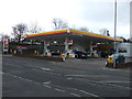
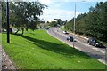
3
Leeming Lane South (A60)
Heading towards Mansfield.
Image: © JThomas
Taken: 16 Mar 2014
0.09 miles
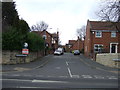
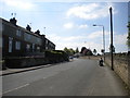
4
A60 towards Warsop, Notts
With the northerly end of Leeming Lane South (the A60) behind the photographer, this is where the A60 crosses Old Mill Lane (the A6117) and continues on towards Market Warsop.
Image: © David Hallam-Jones
Taken: 23 Jan 2016
0.14 miles
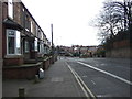
5
Mansfield Woodhouse
Old Mill Lane viewed from JTF car park.
Image: © Alan Heardman
Taken: 8 Feb 2008
0.16 miles
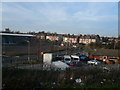
6
Old Mill Lane, Mansfield Woodhouse
View taken from the car park of the DIY store, showing the entrance road to Old Mill Lane Industrial Estate on the left.
Image: © Ann B
Taken: 13 Sep 2005
0.23 miles
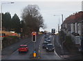
7
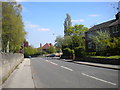
Mansfield Road, Mansfield Woodhouse (1)
Looking towards Mansfield Woodhouse town centre.
Image: © Richard Vince
Taken: 5 May 2018
0.24 miles
8
Mansfield Road, Mansfield Woodhouse (2)
Looking towards Mansfield.
Image: © Richard Vince
Taken: 5 May 2018
0.25 miles