IMAGES TAKEN NEAR TO
Appleby Road, MANSFIELD, NG19 8SW
Introduction
This page details the photographs taken nearby to Appleby Road, NG19 8SW by members of the Geograph project.
The Geograph project started in 2005 with the aim of publishing, organising and preserving representative images for every square kilometre of Great Britain, Ireland and the Isle of Man.

There are currently over 7.5m images from over14,400 individuals and you can help contribute to the project by visiting https://www.geograph.org.uk
Image Map
Images are licensed for reuse under creativecommons.org/licenses/by-sa/2.0
Notes
- Clicking on the map will re-center to the selected point.
- The higher the marker number, the further away the image location is from the centre of the postcode.
Image Listing (54 Images Found)
Images are licensed for reuse under creativecommons.org/licenses/by-sa/2.0
Image
Details
Distance
1
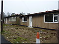
Pre-fabs in Appleby Road
Many unoccupied in this road.
Image: © Peter Barr
Taken: 8 Jan 2013
0.04 miles

5
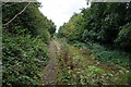
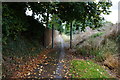
Footpath off Rotherham Road
With conflicting signage.
Image: © JThomas
Taken: 7 Sep 2013
0.08 miles
7
Anthony Bek Primary School
Serving the communities of Pleasley and New Houghton.
Image: © Alan Murray-Rust
Taken: 31 Jan 2010
0.10 miles
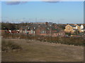
10
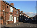
Devonshire Street
Together with Portland Street, the second phase of development of New Houghton, dating from the early years of the 20th century. The large segmental-arched windows are an unusual feature.
Image: © Alan Murray-Rust
Taken: 31 Jan 2010
0.11 miles