IMAGES TAKEN NEAR TO
Wood Lane, MANSFIELD, NG19 8RY
Introduction
This page details the photographs taken nearby to Wood Lane, NG19 8RY by members of the Geograph project.
The Geograph project started in 2005 with the aim of publishing, organising and preserving representative images for every square kilometre of Great Britain, Ireland and the Isle of Man.

There are currently over 7.5m images from over14,400 individuals and you can help contribute to the project by visiting https://www.geograph.org.uk
Image Map
Images are licensed for reuse under creativecommons.org/licenses/by-sa/2.0
Notes
- Clicking on the map will re-center to the selected point.
- The higher the marker number, the further away the image location is from the centre of the postcode.
Image Listing (3 Images Found)
Images are licensed for reuse under creativecommons.org/licenses/by-sa/2.0
Image
Details
Distance
1
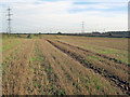
Stubble fields north of Pleasley Park
Looking east across an undulating field, one of many corn fields in this area. The pylons march off to the woodland at Pleasley Park, just in view on the right.
Image: © Trevor Rickard
Taken: 2 Oct 2010
0.18 miles
2
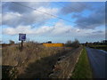
Wood Lane crosses a dismantled railway
The blue sign reads Leen Valley Branch Line (plus licence issued by the Environment Agency).
Image: © Alan Heardman
Taken: 1 Dec 2007
0.20 miles
3
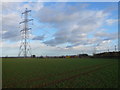
Pylons crossing Farmland
The yellow container marks the point where the former Leen Valley Branch Line meets Wood Lane.
Image: © Alan Heardman
Taken: 1 Dec 2007
0.22 miles