IMAGES TAKEN NEAR TO
Bullock Close, MANSFIELD, NG19 8PH
Introduction
This page details the photographs taken nearby to Bullock Close, NG19 8PH by members of the Geograph project.
The Geograph project started in 2005 with the aim of publishing, organising and preserving representative images for every square kilometre of Great Britain, Ireland and the Isle of Man.

There are currently over 7.5m images from over14,400 individuals and you can help contribute to the project by visiting https://www.geograph.org.uk
Image Map
Images are licensed for reuse under creativecommons.org/licenses/by-sa/2.0
Notes
- Clicking on the map will re-center to the selected point.
- The higher the marker number, the further away the image location is from the centre of the postcode.
Image Listing (12 Images Found)
Images are licensed for reuse under creativecommons.org/licenses/by-sa/2.0
Image
Details
Distance
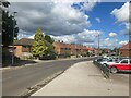
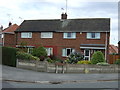
1
Housing on Cox's Lane, Mansfield Woodhouse
Image: © Jonathan Thacker
Taken: 28 Nov 2017
0.13 miles
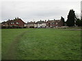
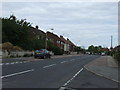
3
Beech Tree Avenue in Mansfield Woodhouse
Image: © Jonathan Clitheroe
Taken: 30 Aug 2023
0.15 miles
4
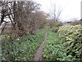
Northfield Lane
This section of the bridleway is little more than a footpath.
Image: © Jonathan Thacker
Taken: 28 Nov 2017
0.17 miles
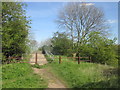
5
Beech Tree Avenue, Mansfield Woodhouse
Heading south.
Image: © JThomas
Taken: 7 Sep 2013
0.18 miles
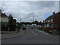
7
Northfield Lane bridge over the railway at Sunnydale
Image: © John Slater
Taken: 4 May 2016
0.20 miles
8
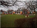
Northfield Primary & Nursery School, Mansfield Woodhouse
Upon Cox's Lane.
Image: © Geoff Dunn
Taken: 12 Feb 2006
0.22 miles
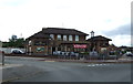
9
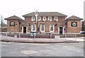
The Sunnydale Public House
Not a particularly sunny day though.
Image: © Geoff Dunn
Taken: 12 Feb 2006
0.22 miles