IMAGES TAKEN NEAR TO
Sookholme, MANSFIELD, NG19 8LW
Introduction
This page details the photographs taken nearby to NG19 8LW by members of the Geograph project.
The Geograph project started in 2005 with the aim of publishing, organising and preserving representative images for every square kilometre of Great Britain, Ireland and the Isle of Man.

There are currently over 7.5m images from over14,400 individuals and you can help contribute to the project by visiting https://www.geograph.org.uk
Image Map
Images are licensed for reuse under creativecommons.org/licenses/by-sa/2.0
Notes
- Clicking on the map will re-center to the selected point.
- The higher the marker number, the further away the image location is from the centre of the postcode.
Image Listing (33 Images Found)
Images are licensed for reuse under creativecommons.org/licenses/by-sa/2.0
Image
Details
Distance
1

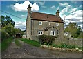
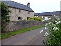
Mill Farm, Sookholme, Notts.
Mill Farm's barn is Grade II-listed, dating from the mid C18th and early C19th. The Sookholme crossroads are 5 minutes walk ahead.
Image: © David Hallam-Jones
Taken: 28 Jan 2016
0.03 miles
2
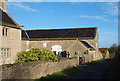
Barn at Mill Farm
The buildings at Mill Farm including the farmhouse are all listed https://historicengland.org.uk/listing/the-list/list-entry/1067609
Image: © Jonathan Thacker
Taken: 9 Sep 2021
0.04 miles
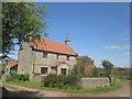
4
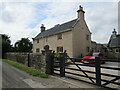
Mill Farm, Sookholme, Notts.
The farm house at Mill Farm dates from c.1750, whilst the barn apparently has mid-C18th and early C19th elements. All are Grade II-listed, including this boundary wall. The Sookholme crossroads are 5 minutes walk away behind the photographer.
Image: © David Hallam-Jones
Taken: 28 Jan 2016
0.05 miles
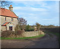
5
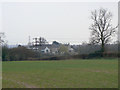
Mill Farm, Sookholme
Seen from the footpath from Warsop Vale.
Image: © Alan Murray-Rust
Taken: 27 Mar 2011
0.05 miles
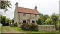
6
Mill Farmhouse, Sookholme
Mid eighteenth century farmhouse https://historicengland.org.uk/listing/the-list/list-entry/1067609
Image: © Jonathan Thacker
Taken: 9 Sep 2021
0.05 miles
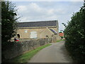
7
Herrings Farm, Sookholme, Notts.
The outskirts of Market Warsop can be reached by a 20-25 minute walk along the unsurfaced rural lane ahead. This farm is situated towards the eastern end of Sookholme Lane, within minutes of both St Augustine's Church and the hamlet of Sookholme. The farm-vehicle size track on the left retains the name Spring Lane despite the fact that within 15-20 metres it becomes a very narrow bridleway joining up with Bully Lane after a 5 minute walk. This secondary path is used by riders and walkers to reach the eastern end of Warsop Vale, a village situated on the northern side of the B6031.
Image: © David Hallam-Jones
Taken: 28 Jan 2016
0.07 miles