IMAGES TAKEN NEAR TO
Brown Avenue, MANSFIELD, NG19 8HJ
Introduction
This page details the photographs taken nearby to Brown Avenue, NG19 8HJ by members of the Geograph project.
The Geograph project started in 2005 with the aim of publishing, organising and preserving representative images for every square kilometre of Great Britain, Ireland and the Isle of Man.

There are currently over 7.5m images from over14,400 individuals and you can help contribute to the project by visiting https://www.geograph.org.uk
Image Map
Images are licensed for reuse under creativecommons.org/licenses/by-sa/2.0
Notes
- Clicking on the map will re-center to the selected point.
- The higher the marker number, the further away the image location is from the centre of the postcode.
Image Listing (11 Images Found)
Images are licensed for reuse under creativecommons.org/licenses/by-sa/2.0
Image
Details
Distance
2
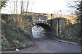
Stone Railway Bridge
Taking the Robin Hood line into Mansfield Woodhouse. Common lane passes underneath.
Image: © Ashley Dace
Taken: 24 Feb 2011
0.13 miles
3
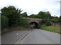
Railway bridge over Common Lane, Mansfield Woodhouse
Image: © JThomas
Taken: 7 Sep 2013
0.13 miles
4
Railway bridge over Common Lane, Mansfield Woodhouse
Image: © John Slater
Taken: 4 May 2016
0.13 miles
7
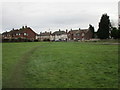
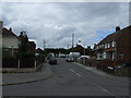
Housing on Cox's Lane, Mansfield Woodhouse
Image: © Jonathan Thacker
Taken: 28 Nov 2017
0.23 miles
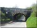
8
Northfield Lane bridge over the railway at Sunnydale
Image: © John Slater
Taken: 4 May 2016
0.23 miles
9
Path known as Northfield Lane, west of railway line near Mansfield Woodhouse
Image: © Colin Park
Taken: 29 Jul 2021
0.24 miles
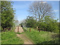
10
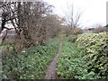
Northfield Lane
This section of the bridleway is little more than a footpath.
Image: © Jonathan Thacker
Taken: 28 Nov 2017
0.25 miles