IMAGES TAKEN NEAR TO
Outgang Lane, MANSFIELD, NG19 8FB
Introduction
This page details the photographs taken nearby to Outgang Lane, NG19 8FB by members of the Geograph project.
The Geograph project started in 2005 with the aim of publishing, organising and preserving representative images for every square kilometre of Great Britain, Ireland and the Isle of Man.

There are currently over 7.5m images from over14,400 individuals and you can help contribute to the project by visiting https://www.geograph.org.uk
Image Map
Images are licensed for reuse under creativecommons.org/licenses/by-sa/2.0
Notes
- Clicking on the map will re-center to the selected point.
- The higher the marker number, the further away the image location is from the centre of the postcode.
Image Listing (87 Images Found)
Images are licensed for reuse under creativecommons.org/licenses/by-sa/2.0
Image
Details
Distance
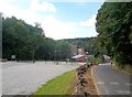
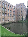
1
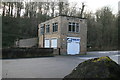
Pleasley Vale Outdoor Activity Centre
Apparently in a former grease works next to the Pleasley Vale textile mill complex.
Image: © Chris Allen
Taken: 16 Feb 2013
0.01 miles
2

Grease works no longer abandoned
The building showing up as "Grease Works" on old maps has been turned into an place specialising in outdoor pursuits. I had a heads up from the guy that was involved a good while ago but have been unable to pop around there for a while. Compare this with how the site look a year or so ago. http://www.geograph.org.uk/photo/468534
(Location GPS tagged by C905)
Image: © James Hill
Taken: 22 Aug 2009
0.01 miles
3
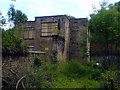
Disused building, Pleasley Vale
A disused and dilapidated building in Pleasley Vale. There was some activity here a few months ago but it appears that all they have done is put some boarding up on the windows. Quite what the building's purpose was, I am not sure. There are two brick built "ponds" behind it and a large doorway to the front and it does appear on early maps (circa 1900) next to the wording "Grease Works" however.
Image: © James Hill
Taken: 16 Jun 2007
0.01 miles
4
Entrance to Pleasley Vale Business Park
View west towards Mill 3 of the converted textile mills.
End of tour - link to first image - Image
Image: © Trevor Rickard
Taken: 2 Oct 2010
0.02 miles
5
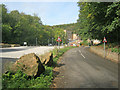
Pleasley Vale
Outgang Lane approaching the mills.
Image: © Alan Heardman
Taken: 29 Sep 2007
0.02 miles
6
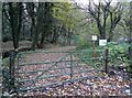
Gateway in Pleasley Vale
To the left, near the trees, The River Meden continues its journey towards the sea.
Image: © Neil Theasby
Taken: 4 Nov 2020
0.03 miles
7
Pleasley Vale
Looking up the valley towards Mill Number 3 which is partially situated in this grid square.
Image: © Jonathan Clitheroe
Taken: 26 Jul 2014
0.04 miles
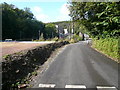
8
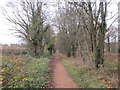
Former railway now cycle path
The route of the former Midland railway line from Mansfield Woodhouse to Tibshelf. The line opened in 1882 but closed in 1964. Passneger traffic never amounted to much and had ceased by 1930 though occasional excursion trains used this route until 1963.
Image: © Jonathan Thacker
Taken: 28 Nov 2017
0.06 miles
9
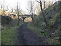
Pleasley Vale - Disused Railway Track Walk
Path runs above Pleasley Vale Mills.
Image: © Alan Heardman
Taken: 1 Jan 2007
0.07 miles
10
Pleasley Mill
This former cotton mill in Pleasley Vale is now very busy again as individual business units. This mill is built on the edge of this square, so close that the water is in the next square west.
Image: © Michael Patterson
Taken: 12 Sep 2006
0.07 miles