IMAGES TAKEN NEAR TO
High Street, MANSFIELD, NG19 7SE
Introduction
This page details the photographs taken nearby to High Street, NG19 7SE by members of the Geograph project.
The Geograph project started in 2005 with the aim of publishing, organising and preserving representative images for every square kilometre of Great Britain, Ireland and the Isle of Man.

There are currently over 7.5m images from over14,400 individuals and you can help contribute to the project by visiting https://www.geograph.org.uk
Image Map
Images are licensed for reuse under creativecommons.org/licenses/by-sa/2.0
Notes
- Clicking on the map will re-center to the selected point.
- The higher the marker number, the further away the image location is from the centre of the postcode.
Image Listing (78 Images Found)
Images are licensed for reuse under creativecommons.org/licenses/by-sa/2.0
Image
Details
Distance
1
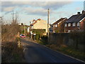
High Street, Pleasleyhill
The name appears to be derived rather from its elevated location on the valley side than on its importance.
Image: © Alan Murray-Rust
Taken: 31 Jan 2010
0.03 miles
2
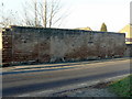
Remains of cottages
Now simply a boundary wall, this was once obviously the front wall of a row of cottages. The fact that these were one residences is indicated by the recesses for boot-scrapers carved into the jambs of the doorways. These cottages would have been cramped even by the standards of Victorian terraces.
Image: © Alan Murray-Rust
Taken: 31 Jan 2010
0.05 miles
3
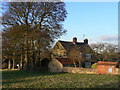
House on High Street
One of the older buildings in the area, dating back to the 18th century. Both the house, and specifically, the boundary wall are Listed grade II.
Image: © Alan Murray-Rust
Taken: 31 Jan 2010
0.06 miles
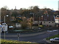
5
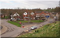
Pleasley NG19, Near Mansfield, Notts.
Meden Square is seen here from the grassed embankment in front of a row of houses situated on Meden Close. The road on the left is Crow Hill and it carries traffic up and down onto this elevated area of land. The parade of shops and houses beyond the lych-gate style bus shelter is a section of the "old" Chesterfield Road. The pink fronted shop is the former post office, now an antique shop.
Image: © David Hallam-Jones
Taken: 28 Apr 2013
0.08 miles
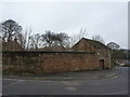
6
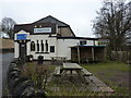
Lakeside, Pleasley
Health and Fitness club, bar and bird-food for sale, and outside picnic tables.
Image: © Peter Barr
Taken: 8 Jan 2013
0.08 miles
7
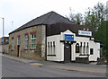
Pleasley - Lakeside Health & Leisure Club
The stone-built part of this club looks like it was once a chapel. Earlier editions of the OS One-Inch map show a place of worship here.
Image: © Dave Bevis
Taken: 20 May 2013
0.08 miles
8
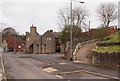
Pleasley NG19, Near Mansfield, Notts
The White Swan has its main entrances on Chesterfield Road. This however, is the view from one side of Meden Square. The stairs and a steep path on the right ascend Meden Bank, formerly Gas Hill.
Image: © David Hallam-Jones
Taken: 28 Apr 2013
0.08 miles
9
Pleasley Mill and pond
A high level view from Meden Bank.
Image: © Alan Murray-Rust
Taken: 31 Jan 2010
0.08 miles
10
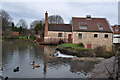
Meden Mill
The 18th century watermill was demolished in the 1950s but the steam mill survives. A steam mill was required as two mills further upstream often took too much water. The sluices and gates are grade II listed.
See also Image]
Image: © Ashley Dace
Taken: 24 Feb 2011
0.08 miles