IMAGES TAKEN NEAR TO
Bagshaw Street, MANSFIELD, NG19 7SD
Introduction
This page details the photographs taken nearby to Bagshaw Street, NG19 7SD by members of the Geograph project.
The Geograph project started in 2005 with the aim of publishing, organising and preserving representative images for every square kilometre of Great Britain, Ireland and the Isle of Man.

There are currently over 7.5m images from over14,400 individuals and you can help contribute to the project by visiting https://www.geograph.org.uk
Image Map
Images are licensed for reuse under creativecommons.org/licenses/by-sa/2.0
Notes
- Clicking on the map will re-center to the selected point.
- The higher the marker number, the further away the image location is from the centre of the postcode.
Image Listing (69 Images Found)
Images are licensed for reuse under creativecommons.org/licenses/by-sa/2.0
Image
Details
Distance
1
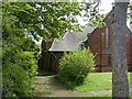
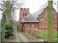
St Barnabas Church, Pleasley
Recreating this 'First' for the square https://www.geograph.org.uk/photo/121559 . Rather more foliage than on the previous visit.
Image: © Alan Murray-Rust
Taken: 7 May 2023
0.05 miles
2
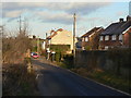
High Street, Pleasleyhill
The name appears to be derived rather from its elevated location on the valley side than on its importance.
Image: © Alan Murray-Rust
Taken: 31 Jan 2010
0.06 miles
3
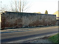
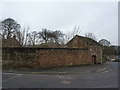
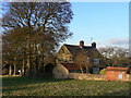
Remains of cottages
Now simply a boundary wall, this was once obviously the front wall of a row of cottages. The fact that these were one residences is indicated by the recesses for boot-scrapers carved into the jambs of the doorways. These cottages would have been cramped even by the standards of Victorian terraces.
Image: © Alan Murray-Rust
Taken: 31 Jan 2010
0.08 miles
4
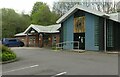
Pleasley Landmark Centre
Recreating this 'First' for the square https://www.geograph.org.uk/photo/46832 . A new entrance has been created in the nearest wing.
Image: © Alan Murray-Rust
Taken: 7 May 2023
0.08 miles
5
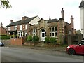
House on High Street
One of the older buildings in the area, dating back to the 18th century. Both the house, and specifically, the boundary wall are Listed grade II.
Image: © Alan Murray-Rust
Taken: 31 Jan 2010
0.09 miles
6
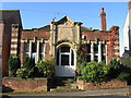
The Old Library, Pleasley Hill
Dated 1906, with the rest of the inscription above the entrance effaced. It was one of the large number of libraries funded by Andrew Carnegie, and the Carnegie Legacy website https://carnegielegacyinengland.wordpress.com/about/home/ has the following information (quoted from elsewhere) 'The architect was John E Goodacre. “Thomas Smith was a Mansfield Town Councillor who lived at 18 Bagshaw Street. By profession he was a builder and donated a piece of land further along the street on which the Free Library was built. . . When the Library was closed, Mansfield Borough Council, as it then was, put the building up for sale for £575. It was bought by a local butcher, Alf Fensome, who had it converted into a bungalow, in which state it still exists today.”' The library is reported as closed as early as 1941, when it was converted to a British Restaurant, although this may have been a temporary wartime expedient rather than permanent closure.
Image: © Alan Murray-Rust
Taken: 7 May 2023
0.10 miles
8
St Barnabas Church, Pleasley
Formed from the parish of St Peter, Mansfield in 1896. Chancel and tower built in 1912.
Image: © Geoff Dunn
Taken: 12 Feb 2006
0.10 miles
9
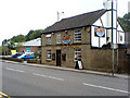
Ye Olde Plough
Ye Olde Plough in Pleasley back in September 2007. The Plough, which dated back to the 1870s, was demolished in December 2019 to make way for a Co-op store.
Image: © James Hill
Taken: 9 Sep 2007
0.11 miles