IMAGES TAKEN NEAR TO
Woburn Lane, MANSFIELD, NG19 7RT
Introduction
This page details the photographs taken nearby to Woburn Lane, NG19 7RT by members of the Geograph project.
The Geograph project started in 2005 with the aim of publishing, organising and preserving representative images for every square kilometre of Great Britain, Ireland and the Isle of Man.

There are currently over 7.5m images from over14,400 individuals and you can help contribute to the project by visiting https://www.geograph.org.uk
Image Map
Images are licensed for reuse under creativecommons.org/licenses/by-sa/2.0
Notes
- Clicking on the map will re-center to the selected point.
- The higher the marker number, the further away the image location is from the centre of the postcode.
Image Listing (30 Images Found)
Images are licensed for reuse under creativecommons.org/licenses/by-sa/2.0
Image
Details
Distance
1
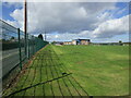
Radford and Hymas Academy
Mansfield Town FC training facility.
Image: © Jonathan Thacker
Taken: 1 Oct 2022
0.06 miles
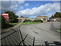
2
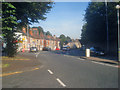
Main road at Pleasleyhill
Looking north along the A617 Chesterfield Road. Local shops and entrance to Poplar Drive on the left.
Image: © Trevor Rickard
Taken: 11 Sep 2009
0.12 miles
3
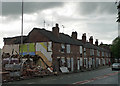
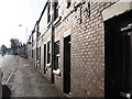
Demolition, Chesterfield Road North, Pleasley
Lots of terraced houses in the village either in the process of being demolished or boarded up and awaiting demolition. All so that new houses can be built ...
Image: © Stephen Richards
Taken: 15 Jun 2012
0.14 miles
4

St Barnabas Church, Pleasley
Formed from the parish of St Peter, Mansfield in 1896. Chancel and tower built in 1912.
Image: © Geoff Dunn
Taken: 12 Feb 2006
0.14 miles
5
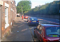
Chesterfield Road
Looking north along the main road. The long terrace here, which looks like a row of Victorian two-up-two-down miners houses, contains several boarded up frontages.
Image: © Trevor Rickard
Taken: 11 Sep 2009
0.15 miles
8

Terraced cottages, Chesterfield Road, Pleasley
These cottages in Pleasley look as if they are scheduled for demolition. Most are boarded up, only a few remain in occupation; see also Image and Image
Image: © Peter Barr
Taken: 19 Aug 2010
0.16 miles
10
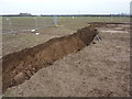
Not the result of an earthquake
Subsidence in a field, on the line of a footpath, on land beneath which lies the workings of the former Pleasley Colliery. I am glad it did not swallow me up, and also spare a thought for the farmer who could have been driving his tractor on this spot.
Image: © Peter Barr
Taken: 8 Jan 2013
0.17 miles