IMAGES TAKEN NEAR TO
Chesterfield Road, MANSFIELD, NG19 7PQ
Introduction
This page details the photographs taken nearby to Chesterfield Road, NG19 7PQ by members of the Geograph project.
The Geograph project started in 2005 with the aim of publishing, organising and preserving representative images for every square kilometre of Great Britain, Ireland and the Isle of Man.

There are currently over 7.5m images from over14,400 individuals and you can help contribute to the project by visiting https://www.geograph.org.uk
Image Map
Images are licensed for reuse under creativecommons.org/licenses/by-sa/2.0
Notes
- Clicking on the map will re-center to the selected point.
- The higher the marker number, the further away the image location is from the centre of the postcode.
Image Listing (176 Images Found)
Images are licensed for reuse under creativecommons.org/licenses/by-sa/2.0
Image
Details
Distance
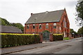
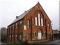
2

Pleasley Village
Church in this old mining village now occupied by an engineering firm
Image: © norman griffin
Taken: 25 Feb 2018
0.03 miles
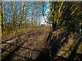
7
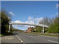
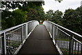
Footbridge over Chesterfield Road, Pleasley
Image: © Steve Fareham
Taken: 8 Apr 2009
0.06 miles
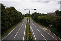
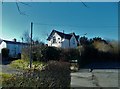
9
Pleasley Village
End of the footbridge crossing the village bypass
Image: © norman griffin
Taken: 25 Feb 2018
0.07 miles