IMAGES TAKEN NEAR TO
Chesterfield Road, MANSFIELD, NG19 7PF
Introduction
This page details the photographs taken nearby to Chesterfield Road, NG19 7PF by members of the Geograph project.
The Geograph project started in 2005 with the aim of publishing, organising and preserving representative images for every square kilometre of Great Britain, Ireland and the Isle of Man.

There are currently over 7.5m images from over14,400 individuals and you can help contribute to the project by visiting https://www.geograph.org.uk
Image Map
Images are licensed for reuse under creativecommons.org/licenses/by-sa/2.0
Notes
- Clicking on the map will re-center to the selected point.
- The higher the marker number, the further away the image location is from the centre of the postcode.
Image Listing (48 Images Found)
Images are licensed for reuse under creativecommons.org/licenses/by-sa/2.0
Image
Details
Distance
2
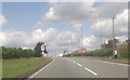
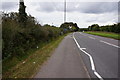
A617 at end of dual carriageway
West of Pleasley
Image: © John Firth
Taken: 19 Jun 2012
0.07 miles
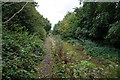
3
Unofficial footpath near New Houghton
Image: © Jonathan Thacker
Taken: 15 Oct 2021
0.09 miles
4
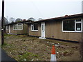
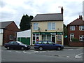
Pre-fabs in Appleby Road
Many unoccupied in this road.
Image: © Peter Barr
Taken: 8 Jan 2013
0.10 miles
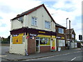
6
Coronation Avenue
Semi-detached houses and parked cars.
Image: © Peter Barr
Taken: 8 Jan 2013
0.11 miles
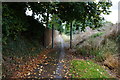
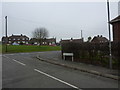
9
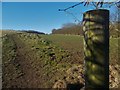
Pleasley Village
Track across the field but hidden from the bypass nearby
Image: © norman griffin
Taken: 25 Feb 2018
0.12 miles