IMAGES TAKEN NEAR TO
Shaftesbury Avenue, MANSFIELD, NG19 7ND
Introduction
This page details the photographs taken nearby to Shaftesbury Avenue, NG19 7ND by members of the Geograph project.
The Geograph project started in 2005 with the aim of publishing, organising and preserving representative images for every square kilometre of Great Britain, Ireland and the Isle of Man.

There are currently over 7.5m images from over14,400 individuals and you can help contribute to the project by visiting https://www.geograph.org.uk
Image Map
Images are licensed for reuse under creativecommons.org/licenses/by-sa/2.0
Notes
- Clicking on the map will re-center to the selected point.
- The higher the marker number, the further away the image location is from the centre of the postcode.
Image Listing (11 Images Found)
Images are licensed for reuse under creativecommons.org/licenses/by-sa/2.0
Image
Details
Distance
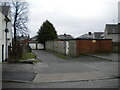
4
Footpath across Bright Square, Bull Farm
Leading from Booth Crescent (foreground) to Peel Crescent.
Image: © Richard Vince
Taken: 12 Dec 2020
0.17 miles
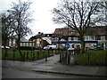
6
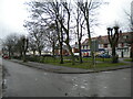
Bright Square, Bull Farm
A small green near the middle of the estate, between Booth Crescent (foreground) and Peel Crescent.
Image: © Richard Vince
Taken: 12 Dec 2020
0.19 miles
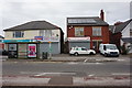
7
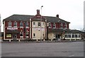
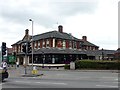
The Rufford Arms Pub, Mansfield
At the junctions oa A617 & A6075.
Image: © Geoff Dunn
Taken: 12 Feb 2006
0.19 miles
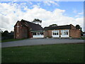
10
The Rufford
A large public house and restaurant where a carvery lunch cost just £3.99
Image: © Graham Hogg
Taken: 12 Jun 2017
0.22 miles