IMAGES TAKEN NEAR TO
Debdale Lane, MANSFIELD, NG19 7EZ
Introduction
This page details the photographs taken nearby to Debdale Lane, NG19 7EZ by members of the Geograph project.
The Geograph project started in 2005 with the aim of publishing, organising and preserving representative images for every square kilometre of Great Britain, Ireland and the Isle of Man.

There are currently over 7.5m images from over14,400 individuals and you can help contribute to the project by visiting https://www.geograph.org.uk
Image Map
Images are licensed for reuse under creativecommons.org/licenses/by-sa/2.0
Notes
- Clicking on the map will re-center to the selected point.
- The higher the marker number, the further away the image location is from the centre of the postcode.
Image Listing (4 Images Found)
Images are licensed for reuse under creativecommons.org/licenses/by-sa/2.0
Image
Details
Distance
1
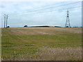
Pylon on farmland
A pylon on some farmland off Debdale Lane.
Image: © James Hill
Taken: 9 Sep 2007
0.20 miles
2
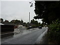
Bungalows on Debdale Lane, Mansfield Woodhouse
Image: © Peter Barr
Taken: 16 Aug 2013
0.21 miles
3
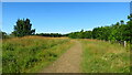
Path over landscaped former colliery site west of Mansfield Woodhouse Station
It is now possible to walk between Mansfield Woodhouse Station and Creswell Station using a series of good gravel paths suitable for all seasons and crossing landscaped former colliery sites.
Image: © Colin Park
Taken: 29 Jul 2021
0.22 miles