IMAGES TAKEN NEAR TO
West Bank Avenue, MANSFIELD, NG19 7DJ
Introduction
This page details the photographs taken nearby to West Bank Avenue, NG19 7DJ by members of the Geograph project.
The Geograph project started in 2005 with the aim of publishing, organising and preserving representative images for every square kilometre of Great Britain, Ireland and the Isle of Man.

There are currently over 7.5m images from over14,400 individuals and you can help contribute to the project by visiting https://www.geograph.org.uk
Image Map
Images are licensed for reuse under creativecommons.org/licenses/by-sa/2.0
Notes
- Clicking on the map will re-center to the selected point.
- The higher the marker number, the further away the image location is from the centre of the postcode.
Image Listing (22 Images Found)
Images are licensed for reuse under creativecommons.org/licenses/by-sa/2.0
Image
Details
Distance
1
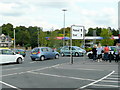
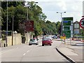
Tesco car park exit and petrol station
Looking towards the A617 Chesterfield Road.
Image: © Jonathan Billinger
Taken: 7 Sep 2009
0.13 miles
2
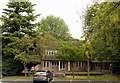
Innisdoon, Crow Hill Drive, Mansfield
A large house in Arts and Crafts style, now converted to office use. 1904-05, by Barry Parker and Raymond Unwin for Walter Barringer of Mansfield. Listed Grade II*.
A glimpse of the west side of the house.
Image: © Alan Murray-Rust
Taken: 21 Aug 2019
0.14 miles
3
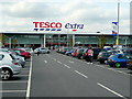
Tesco megastore, Mansfield
Adjacent to the A617 Chesterfield Road.
Image: © Jonathan Billinger
Taken: 7 Sep 2009
0.14 miles
4
Innisdoon, Crow Hill Drive, Mansfield
A large house in Arts and Crafts style, now converted to office use. 1904-05, by Barry Parker and Raymond Unwin for Walter Barringer of Mansfield. Listed Grade II*. The gates and boundary wall are included in the description.
Image: © Alan Murray-Rust
Taken: 21 Aug 2019
0.14 miles
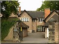
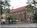
6
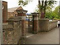
Gateway and walls, Catholic Church of St Philip Neri, Mansfield
The straight sections of wall are 19th century, belonging to Westfield House, in whose grounds the church was built. The gateway was inserted when the church was built in 1925. Listed Grade II separately from the church.
Image: © Alan Murray-Rust
Taken: 21 Aug 2019
0.18 miles
7
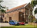
Catholic Church of St Philip Neri, Mansfield
Dated 1925, by London architect Charles A Easton. Listed Grade II.
Image: © Alan Murray-Rust
Taken: 21 Aug 2019
0.18 miles
8
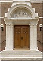
Main doorway, Catholic Church of St Philip Neri, Mansfield
There is a fine sculpture in the tympanum but I have been unable to identify what it depicts. It is likely to be representative of St Philip Neri, the dedicatee of the church. See http://www.geograph.org.uk/photo/6256656 for location.
Image: © Alan Murray-Rust
Taken: 21 Aug 2019
0.18 miles
9
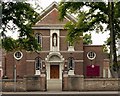
Catholic Church of St Philip Neri, Mansfield
Dated 1925, by London architect Charles A Easton. Listed Grade II. The wall and gates are separately Listed Grade II.
Image: © Alan Murray-Rust
Taken: 21 Aug 2019
0.18 miles
10
Mansfield - St Philip RC Church
On Chesterfield Road South. Roman Catholic church of St Philip Neri and attached presbytery. Dated 1925. Architect Charles A Easdon of London. See: http://www.grasshopper-hosting.co.uk/Diocese/02_Admin/AHP/Final%20report%20(PDF)/Sherwood%20Deanery/Mansfield,%20St%20Philip%20Neri(NXPowerLite).pdf
Image: © Dave Bevis
Taken: 17 Sep 2013
0.18 miles