IMAGES TAKEN NEAR TO
Brockenhurst Road, MANSFIELD, NG19 6TX
Introduction
This page details the photographs taken nearby to Brockenhurst Road, NG19 6TX by members of the Geograph project.
The Geograph project started in 2005 with the aim of publishing, organising and preserving representative images for every square kilometre of Great Britain, Ireland and the Isle of Man.

There are currently over 7.5m images from over14,400 individuals and you can help contribute to the project by visiting https://www.geograph.org.uk
Image Map
Images are licensed for reuse under creativecommons.org/licenses/by-sa/2.0
Notes
- Clicking on the map will re-center to the selected point.
- The higher the marker number, the further away the image location is from the centre of the postcode.
Image Listing (16 Images Found)
Images are licensed for reuse under creativecommons.org/licenses/by-sa/2.0
Image
Details
Distance
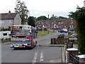
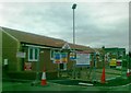
3
To the football club changing rooms down Birks Road
Image: © Chris Morgan
Taken: 12 Jun 2017
0.13 miles
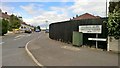
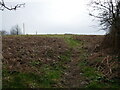
4
Solar powered electric fence by Fishpond Hill
Image: © Chris Morgan
Taken: 12 Jun 2017
0.14 miles
5
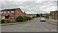
James Chapman Homes, development, Mansfield
Image: © Alex McGregor
Taken: 15 Feb 2012
0.14 miles
6
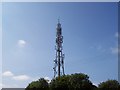
Mansfield Transmitter
Mansfield's Transmitter that broadcasts Mansfield 103.2 Radio.
Image: © Jack
Taken: 25 Aug 2007
0.15 miles
9
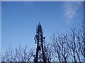
Mansfield Transmitter viewed from below
Taken below the transmitter.
Image: © Jack
Taken: 2 Mar 2008
0.20 miles
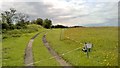
10
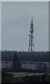
Fishpond Hill Mast, Mansfield
Taken from the position where the Teversal Trail crosses Newbound Lane, Teversal .
Image: © Paul Heaton
Taken: 6 Mar 2020
0.21 miles