IMAGES TAKEN NEAR TO
Penniment Lane, MANSFIELD, NG19 6PH
Introduction
This page details the photographs taken nearby to Penniment Lane, NG19 6PH by members of the Geograph project.
The Geograph project started in 2005 with the aim of publishing, organising and preserving representative images for every square kilometre of Great Britain, Ireland and the Isle of Man.

There are currently over 7.5m images from over14,400 individuals and you can help contribute to the project by visiting https://www.geograph.org.uk
Image Map
Images are licensed for reuse under creativecommons.org/licenses/by-sa/2.0
Notes
- Clicking on the map will re-center to the selected point.
- The higher the marker number, the further away the image location is from the centre of the postcode.
Image Listing (12 Images Found)
Images are licensed for reuse under creativecommons.org/licenses/by-sa/2.0
Image
Details
Distance
1
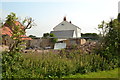
House with possible building site
Rubble at the side of a house on Penniment Lane.
Image: © Peter Barr
Taken: 8 Jul 2012
0.03 miles
3
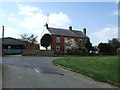
Farm Shop, Penniment House Farm
At junction of Penniment Lane and Top Lane, north of Skegby.
Image: © Peter Barr
Taken: 8 Jul 2012
0.04 miles
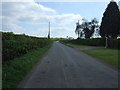
4
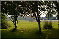
Penniment Lodge Farm
Towards Penniment Lodge Farmnear Mansfield
Image: © Keith Havercroft
Taken: 16 Apr 2006
0.05 miles
8
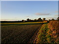
Autumn sown field and Penniment House Farm
Image: © Jonathan Thacker
Taken: 25 Oct 2021
0.09 miles
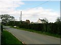
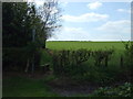
9
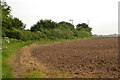
Footpath round ploughed field
From Penniment Lodge Farm, towards Bull Farm.
Image: © Peter Barr
Taken: 8 Jul 2012
0.15 miles
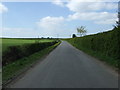
10
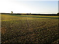
Trace of a footpath
The field has been sown but the path has been sufficiently walked to be traceable.
Image: © Jonathan Thacker
Taken: 25 Oct 2021
0.17 miles