IMAGES TAKEN NEAR TO
Salisbury Road, MANSFIELD, NG19 6EY
Introduction
This page details the photographs taken nearby to Salisbury Road, NG19 6EY by members of the Geograph project.
The Geograph project started in 2005 with the aim of publishing, organising and preserving representative images for every square kilometre of Great Britain, Ireland and the Isle of Man.

There are currently over 7.5m images from over14,400 individuals and you can help contribute to the project by visiting https://www.geograph.org.uk
Image Map
Images are licensed for reuse under creativecommons.org/licenses/by-sa/2.0
Notes
- Clicking on the map will re-center to the selected point.
- The higher the marker number, the further away the image location is from the centre of the postcode.
Image Listing (8 Images Found)
Images are licensed for reuse under creativecommons.org/licenses/by-sa/2.0
Image
Details
Distance
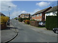
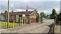
1

Redgate Public House, Mansfield
At junction of Redgate Street & Westfield Lane, Mansfield.
Image: © Geoff Dunn
Taken: 12 Feb 2006
0.11 miles
2
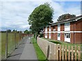
Public footpath in Ladybrook
Running between Clarendon Road and the grounds of the Flying High Academy, a newly-built primary school
Image: © Graham Hogg
Taken: 12 Jun 2017
0.13 miles
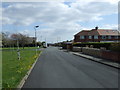

8
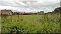
Recreation field off Hall Barn Lane, Mansfield
Image: © Chris Morgan
Taken: 12 Jun 2017
0.21 miles