IMAGES TAKEN NEAR TO
Broomhill Lane, MANSFIELD, NG19 6BW
Introduction
This page details the photographs taken nearby to Broomhill Lane, NG19 6BW by members of the Geograph project.
The Geograph project started in 2005 with the aim of publishing, organising and preserving representative images for every square kilometre of Great Britain, Ireland and the Isle of Man.

There are currently over 7.5m images from over14,400 individuals and you can help contribute to the project by visiting https://www.geograph.org.uk
Image Map
Images are licensed for reuse under creativecommons.org/licenses/by-sa/2.0
Notes
- Clicking on the map will re-center to the selected point.
- The higher the marker number, the further away the image location is from the centre of the postcode.
Image Listing (7 Images Found)
Images are licensed for reuse under creativecommons.org/licenses/by-sa/2.0
Image
Details
Distance
3
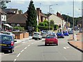
Chesterfield Road South, Mansfield
Looking towards Pleasley.
Image: © Richard Vince
Taken: 31 Oct 2015
0.22 miles
4
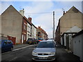
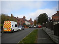
Bottom of Linden Street, Mansfield
A very busy cul de sac off Chesterfield Road South, to the north west of Mansfield town centre. The presence of a fancy dress shop just behind the photographer may have contributed to the busyness of the street on Hallowe'en.
Image: © Richard Vince
Taken: 31 Oct 2015
0.23 miles
5

Redgate Public House, Mansfield
At junction of Redgate Street & Westfield Lane, Mansfield.
Image: © Geoff Dunn
Taken: 12 Feb 2006
0.23 miles
6
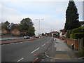
Perlethorpe Avenue, Mansfield
A cul de sac off Chesterfield Road South, to the north west of Mansfield town centre.
Image: © Richard Vince
Taken: 31 Oct 2015
0.24 miles
7
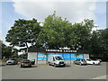
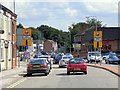
Tanning Lounge, Chesterfield Road, Mansfield
Image: © Jonathan Thacker
Taken: 9 Sep 2021
0.25 miles