IMAGES TAKEN NEAR TO
Goldcrest Road, MANSFIELD, NG19 0GP
Introduction
This page details the photographs taken nearby to Goldcrest Road, NG19 0GP by members of the Geograph project.
The Geograph project started in 2005 with the aim of publishing, organising and preserving representative images for every square kilometre of Great Britain, Ireland and the Isle of Man.

There are currently over 7.5m images from over14,400 individuals and you can help contribute to the project by visiting https://www.geograph.org.uk
Image Map
Images are licensed for reuse under creativecommons.org/licenses/by-sa/2.0
Notes
- Clicking on the map will re-center to the selected point.
- The higher the marker number, the further away the image location is from the centre of the postcode.
Image Listing (26 Images Found)
Images are licensed for reuse under creativecommons.org/licenses/by-sa/2.0
Image
Details
Distance
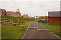
1

Path from Stinting Lane to Goldcrest Road, Mansfield
Image: © Jonathan Thacker
Taken: 13 Jan 2022
0.03 miles
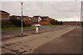
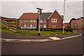
4

Grass field off Stinting Lane
Mansfield Woodhouse in the distance.
Image: © Jonathan Thacker
Taken: 13 Jan 2022
0.11 miles
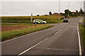
5
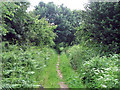
Stinting Lane heading SW
I quickly took this image before the swarms of black flies could eat me alive! This just shows the dirt track path and the surrounding flora.
Image: © James Hill
Taken: 8 Jun 2007
0.11 miles
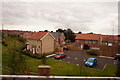
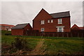
10

Recent housing below Stinting Lane
Image: © Jonathan Thacker
Taken: 13 Jan 2022
0.13 miles