IMAGES TAKEN NEAR TO
Linden Road, MANSFIELD, NG19 0EL
Introduction
This page details the photographs taken nearby to Linden Road, NG19 0EL by members of the Geograph project.
The Geograph project started in 2005 with the aim of publishing, organising and preserving representative images for every square kilometre of Great Britain, Ireland and the Isle of Man.

There are currently over 7.5m images from over14,400 individuals and you can help contribute to the project by visiting https://www.geograph.org.uk
Image Map
Images are licensed for reuse under creativecommons.org/licenses/by-sa/2.0
Notes
- Clicking on the map will re-center to the selected point.
- The higher the marker number, the further away the image location is from the centre of the postcode.
Image Listing (13 Images Found)
Images are licensed for reuse under creativecommons.org/licenses/by-sa/2.0
Image
Details
Distance

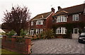
2
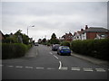
Woodland Road, Forest Town
Off Ellesmere Road.
Image: © Richard Vince
Taken: 15 Aug 2020
0.09 miles
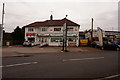
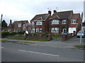
5
Sherwood Hall Road, Forest Town
Looking towards Clipstone from outside the Samworth Church Academy.
Image: © Richard Vince
Taken: 15 Aug 2020
0.19 miles
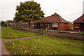
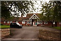
6
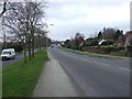
Clipstone Road West (B6030)
Heading south west.
Image: © JThomas
Taken: 17 Mar 2014
0.20 miles