IMAGES TAKEN NEAR TO
Wood Close, MANSFIELD, NG19 0EH
Introduction
This page details the photographs taken nearby to Wood Close, NG19 0EH by members of the Geograph project.
The Geograph project started in 2005 with the aim of publishing, organising and preserving representative images for every square kilometre of Great Britain, Ireland and the Isle of Man.

There are currently over 7.5m images from over14,400 individuals and you can help contribute to the project by visiting https://www.geograph.org.uk
Image Map
Images are licensed for reuse under creativecommons.org/licenses/by-sa/2.0
Notes
- Clicking on the map will re-center to the selected point.
- The higher the marker number, the further away the image location is from the centre of the postcode.
Image Listing (26 Images Found)
Images are licensed for reuse under creativecommons.org/licenses/by-sa/2.0
Image
Details
Distance
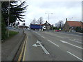
2
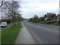
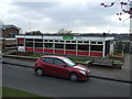
Clipstone Road West (B6030)
Heading south west.
Image: © JThomas
Taken: 17 Mar 2014
0.04 miles
7
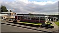
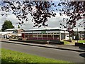
Forest Town Library, Mansfield
Note solar panels on roof
Image: © Chris Morgan
Taken: 3 Oct 2017
0.08 miles
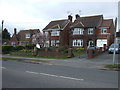
8
Woodland Road, Forest Town
Off Ellesmere Road.
Image: © Richard Vince
Taken: 15 Aug 2020
0.09 miles
9
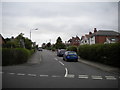
Pump Hollow Road (A6117)
Approaching traffic lights.
Image: © JThomas
Taken: 17 Mar 2014
0.11 miles
10
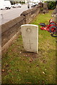
Nurse Ada Elizabeth Young, St Alban the Martyr
Killed on 15th July 1918 aged 33. Voluntary Aid Detachment. Member of the British Red Cross, Order or St John.
Image: © Ian S
Taken: 8 Oct 2016
0.11 miles