IMAGES TAKEN NEAR TO
Second Avenue, MANSFIELD, NG19 0BG
Introduction
This page details the photographs taken nearby to Second Avenue, NG19 0BG by members of the Geograph project.
The Geograph project started in 2005 with the aim of publishing, organising and preserving representative images for every square kilometre of Great Britain, Ireland and the Isle of Man.

There are currently over 7.5m images from over14,400 individuals and you can help contribute to the project by visiting https://www.geograph.org.uk
Image Map
Images are licensed for reuse under creativecommons.org/licenses/by-sa/2.0
Notes
- Clicking on the map will re-center to the selected point.
- The higher the marker number, the further away the image location is from the centre of the postcode.
Image Listing (36 Images Found)
Images are licensed for reuse under creativecommons.org/licenses/by-sa/2.0
Image
Details
Distance
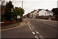
1
First Avenue (left) and Second Avenue (right) Forest Town, Mansfield
Image: © Chris Morgan
Taken: 3 Oct 2017
0.02 miles
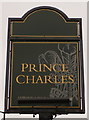
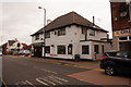
3
Prince Charles, Clipstone Road West, Forest Town, Mansfield
Image: © Chris Morgan
Taken: 3 Oct 2017
0.04 miles
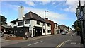
5
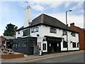
The Prince Charles
A two room public house on Clipstone Road West
Image: © Graham Hogg
Taken: 3 Oct 2017
0.05 miles
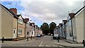
8
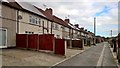
Typical Avenue, Forest Town, Mansfield
These parallel Avenues are numbered from 1-9
Image: © Chris Morgan
Taken: 3 Oct 2017
0.10 miles
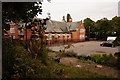
9
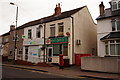
Post Office on Clipstone Road West
Forest Town.
Image: © Ian S
Taken: 8 Oct 2016
0.10 miles