IMAGES TAKEN NEAR TO
NG18 9NQ
Introduction
This page details the photographs taken nearby to NG18 9NQ by members of the Geograph project.
The Geograph project started in 2005 with the aim of publishing, organising and preserving representative images for every square kilometre of Great Britain, Ireland and the Isle of Man.

There are currently over 7.5m images from over14,400 individuals and you can help contribute to the project by visiting https://www.geograph.org.uk
Image Map
Images are licensed for reuse under creativecommons.org/licenses/by-sa/2.0
Notes
- Clicking on the map will re-center to the selected point.
- The higher the marker number, the further away the image location is from the centre of the postcode.
Image Listing (6 Images Found)
Images are licensed for reuse under creativecommons.org/licenses/by-sa/2.0
Image
Details
Distance
2
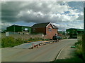
Old Mill Lane, Mansfield Woodhouse
View taken from the car park of the DIY store, showing the entrance road to Old Mill Lane Industrial Estate on the left.
Image: © Ann B
Taken: 13 Sep 2005
0.15 miles
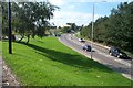
3
Mansfield Woodhouse
Old Mill Lane viewed from JTF car park.
Image: © Alan Heardman
Taken: 8 Feb 2008
0.21 miles
4
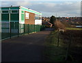
Windmill Lane, Mansfield, Notts.
A right-hand glance when standing in front of the entrance gates that provide access into the south-west corner of the Brunt's Academy provides a view of this building, "The Mansfield Community Performance Centre". Since this building is on the Brunt's Academy site perhaps it is safe to assume that the building was (or is) a jointly funded venture? The Brunts Academy is a large secondary school that specialises in the Performing Arts. Brunts has been a Grammar School and a Technical School in the past and it traces its foundation to a bequest by Samuel Brunts in 1709. This was the year that Samuel Brunts left a bequest that was used by an Elementary School to assist local children "to learn an honest trade". The Brunts School became The Brunts Academy on 1st January 2012.
Image: © David Hallam-Jones
Taken: 8 Jan 2015
0.21 miles
5
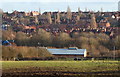
Off Windmill Lane, Mansfield, Notts.
A view from near the closed end of this cul-de-sac, across a field that appears to be used for grazing horses. Near to the photographer's left is an entrance into the south-west corner of the Brunts Academy. The long, low building at the foot of this field is also part of the school, served by an extremely long drive that branches off Bath Lane. This is a large secondary school that specialises in the Performing Arts. Brunts has been a Grammar School and a Technical School in the past and it traces its foundation to a bequest by Samuel Brunts in 1709. This was the year that Samuel Brunts left a bequest that was used by an Elementary School to assist local children "to learn an honest trade". The Brunts School became The Brunts Academy on 1st January 2012.
Image: © David Hallam-Jones
Taken: 8 Jan 2015
0.23 miles
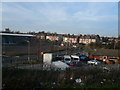
6
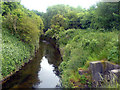
Inlet into river Maun
Taken from the side of Old Mill Lane. One of the inlets can be seen in the bottom right of the picture.
Image: © James Hill
Taken: 8 Jun 2007
0.24 miles