IMAGES TAKEN NEAR TO
Jenford Street, MANSFIELD, NG18 5QX
Introduction
This page details the photographs taken nearby to Jenford Street, NG18 5QX by members of the Geograph project.
The Geograph project started in 2005 with the aim of publishing, organising and preserving representative images for every square kilometre of Great Britain, Ireland and the Isle of Man.

There are currently over 7.5m images from over14,400 individuals and you can help contribute to the project by visiting https://www.geograph.org.uk
Image Map
Images are licensed for reuse under creativecommons.org/licenses/by-sa/2.0
Notes
- Clicking on the map will re-center to the selected point.
- The higher the marker number, the further away the image location is from the centre of the postcode.
Image Listing (8 Images Found)
Images are licensed for reuse under creativecommons.org/licenses/by-sa/2.0
Image
Details
Distance
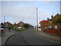
2
Sutton Road (A38), Mansfield
Heading south west.
Image: © JThomas
Taken: 16 Mar 2014
0.22 miles
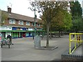
3

Entrance to Botany Commercial Park, Mansfield
A small private industrial estate off Botany Avenue.
Image: © Richard Vince
Taken: 31 Oct 2015
0.22 miles

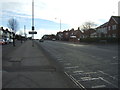
7

Sutton Road, Mansfield
Looking towards Mansfield town centre along the A38, with Moor Lane leading off to the right. This is getting very close to the northern end of the A38 - in the other direction it runs to Bodmin in Cornwall, nearly 300 miles away.
Image: © Stephen McKay
Taken: 23 Jul 2016
0.25 miles
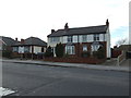
8
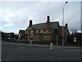
The Sir John Cockle pub, Mansfield
On Sutton Road.
Image: © JThomas
Taken: 16 Mar 2014
0.25 miles