IMAGES TAKEN NEAR TO
Heather Close, MANSFIELD, NG18 5QL
Introduction
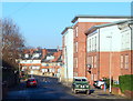
This page details the photographs taken nearby to Heather Close, NG18 5QL by members of the Geograph project.
The Geograph project started in 2005 with the aim of publishing, organising and preserving representative images for every square kilometre of Great Britain, Ireland and the Isle of Man.

There are currently over 7.5m images from over14,400 individuals and you can help contribute to the project by visiting https://www.geograph.org.uk
Image Map
Images are licensed for reuse under creativecommons.org/licenses/by-sa/2.0
Notes
- Clicking on the map will re-center to the selected point.
- The higher the marker number, the further away the image location is from the centre of the postcode.
Image Listing (96 Images Found)
Images are licensed for reuse under creativecommons.org/licenses/by-sa/2.0
Image
Details
Distance
1
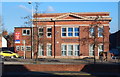
Stockwell Gate, Mansfield, Notts.
The North Nottinghamshire Business Centre on the opposite side of the A38. The yellow car is travelling in the direction of the town centre.
Image: © David Hallam-Jones
Taken: 20 Jan 2016
0.01 miles
2

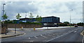
Service station on Stockwell Gate, Mansfield
Image: © JThomas
Taken: 16 Mar 2014
0.04 miles
3
Community Hospital, Mansfield, Notts.
The main entrance to the Mansfield Community Hospital site on Stockwell Gate (the A38). This hospital occupies the site of Mansfield's former Workhouse. It closed in March 1930 and the building was demolished in 2007. The solitary car is heading out of the town centre towards Mansfield Road and King's Mill Hospital. Four hospitals, i.e. King's Mill, Newark General, Ashfield Community Hospital, plus this one, are all part of the Sherwood Forest NHS Foundation Trust.
Image: © David Hallam-Jones
Taken: 16 Jun 2013
0.05 miles
4

Community Hospital, Mansfield, Notts.
The pedestrian entrance to the Community Hospital site, off Stockwell Gate (the A38). Four hospitals, i.e. King's Mill, Newark General, Ashfield Community Hospital and this one are all part of the Sherwood Forest NHS Foundation Trust. Mansfield's Workhouse was previously located on this site. It closed in 1930 and its buildings were demolished in 2003.
Image: © David Hallam-Jones
Taken: 16 Jun 2013
0.07 miles
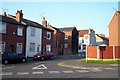
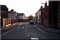
7
Dallas Street, Mansfield, Notts.
Dallas Street is seen here the approach to its T junction with the busy A38 (a.k.a. Stockwell Gate).
Image: © David Hallam-Jones
Taken: 20 Jan 2016
0.08 miles
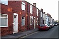
9
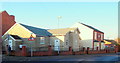
Dallas Street, Mansfield, Notts.
Dallas Street curves round from the left, passes this Spiritualist Church, and within a minute's walk joins the busy A38 (a.k.a. Stockwell Gate) at a T junction.
Image: © David Hallam-Jones
Taken: 20 Jan 2016
0.10 miles
10
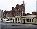
Mansfield - The Red
Properly called the Red Lion. On Stockwell Gate.
Image: © Dave Bevis
Taken: 14 Apr 2011
0.10 miles