IMAGES TAKEN NEAR TO
Castle Street, MANSFIELD, NG18 5PP
Introduction
This page details the photographs taken nearby to Castle Street, NG18 5PP by members of the Geograph project.
The Geograph project started in 2005 with the aim of publishing, organising and preserving representative images for every square kilometre of Great Britain, Ireland and the Isle of Man.

There are currently over 7.5m images from over14,400 individuals and you can help contribute to the project by visiting https://www.geograph.org.uk
Image Map
Images are licensed for reuse under creativecommons.org/licenses/by-sa/2.0
Notes
- Clicking on the map will re-center to the selected point.
- The higher the marker number, the further away the image location is from the centre of the postcode.
Image Listing (15 Images Found)
Images are licensed for reuse under creativecommons.org/licenses/by-sa/2.0
Image
Details
Distance
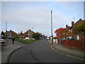
1

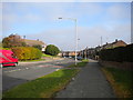
Botany Avenue, Mansfield
Seen from the junction with Bancroft Lane, Botany Avenue is residential at this end, giving way to a light industrial area further south.
Image: © Stephen McKay
Taken: 23 Jul 2016
0.12 miles
3

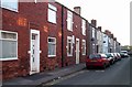
Bottom of Winkburn Road, Mansfield
A residential cul de sac off Ladybrook Lane.
Image: © Richard Vince
Taken: 31 Oct 2015
0.15 miles


10

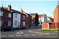
Entrance to Botany Commercial Park, Mansfield
A small private industrial estate off Botany Avenue.
Image: © Richard Vince
Taken: 31 Oct 2015
0.23 miles