IMAGES TAKEN NEAR TO
Hermitage Lane, MANSFIELD, NG18 5HA
Introduction
This page details the photographs taken nearby to Hermitage Lane, NG18 5HA by members of the Geograph project.
The Geograph project started in 2005 with the aim of publishing, organising and preserving representative images for every square kilometre of Great Britain, Ireland and the Isle of Man.

There are currently over 7.5m images from over14,400 individuals and you can help contribute to the project by visiting https://www.geograph.org.uk
Image Map
Images are licensed for reuse under creativecommons.org/licenses/by-sa/2.0
Notes
- Clicking on the map will re-center to the selected point.
- The higher the marker number, the further away the image location is from the centre of the postcode.
Image Listing (15 Images Found)
Images are licensed for reuse under creativecommons.org/licenses/by-sa/2.0
Image
Details
Distance
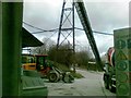
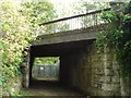
1
Railway bridge over Hermitage Lane
Looking north.
Robin Hood Line between Worksop and Nottingham.
Image: © JThomas
Taken: 18 Apr 2014
0.09 miles
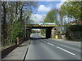
2
Railway bridge over Hermitage Lane
Looking south.
Robin Hood Line between Worksop and Nottingham.
Image: © JThomas
Taken: 18 Apr 2014
0.09 miles
3
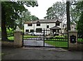
Grand house on King's Lodge Lane, Mansfield
Image: © Neil Theasby
Taken: 20 Jul 2019
0.12 miles
4
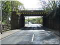
Railway Bridge Behind Hermitage Mill
This surprisingly fancy little bridge carries the Robin Hood Line over a track which used to be the back entrance to Hermitage Mill.
Image: © Antony Dixon
Taken: 23 Sep 2011
0.14 miles
5
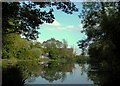
Hermitage Mill Pond
The mill pond is now used as a fishing lake - some of the buildings of the old mill itself can be seen behind the trees.
Image: © Antony Dixon
Taken: 23 Sep 2011
0.15 miles
6
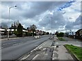
A38 Road in Mansfield
Arterial route into the town from the west.
Image: © Jonathan Clitheroe
Taken: 13 Apr 2022
0.16 miles
7
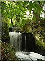
Outfall from Hermitage Mill Pond
The River Maun continues its journey towards Mansfield.
Image: © Antony Dixon
Taken: 23 Sep 2011
0.17 miles
8
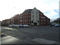
Apartments on Sutton Road, Mansfield
Handy for the Sir John Cockle pub across the road.
Image: © JThomas
Taken: 16 Mar 2014
0.17 miles
9
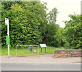
Oakham Nature Reserve, Mansfield, Notts.
The start (or conclusion) of the northern section of this local nature reserve (LNR) seen from Hermitage Way in the Bleak Hills area of Mansfield. The River Maun passes beneath this road and continues - out in the open - behind the photographer.
Image: © David Hallam-Jones
Taken: 16 Jun 2013
0.18 miles