IMAGES TAKEN NEAR TO
Hamilton Court, MANSFIELD, NG18 5FB
Introduction
This page details the photographs taken nearby to Hamilton Court, NG18 5FB by members of the Geograph project.
The Geograph project started in 2005 with the aim of publishing, organising and preserving representative images for every square kilometre of Great Britain, Ireland and the Isle of Man.

There are currently over 7.5m images from over14,400 individuals and you can help contribute to the project by visiting https://www.geograph.org.uk
Image Map
Images are licensed for reuse under creativecommons.org/licenses/by-sa/2.0
Notes
- Clicking on the map will re-center to the selected point.
- The higher the marker number, the further away the image location is from the centre of the postcode.
Image Listing (39 Images Found)
Images are licensed for reuse under creativecommons.org/licenses/by-sa/2.0
Image
Details
Distance
1
Oakham Nature Reserve, Mansfield, Notts.
The Hamilton Way entrance into the southern section of this local nature reserve (LNR).
Image: © David Hallam-Jones
Taken: 16 Jun 2013
0.03 miles
2
Oakham Nature Reserve, Mansfield, Notts.
Hamilton Way (ahead) is the cross-over point between the northern section and the southern sections of this local nature reserve. Access to the southern section is via a stile behind the belisha beacon.
Image: © David Hallam-Jones
Taken: 16 Jun 2013
0.04 miles
3
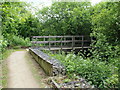
Oakham Nature Reserve, Mansfield, Notts.
A wooden bridge crosses the River Maun in the northern section of this local nature reserve. The mid-point of the overall route, i.e. where the path crosses Hamilton Way and the next section, the southern section, is accessed is 3-4 minutes walk ahead. The end (or start) of this northern section, i.e. on Hermitage Lane, is 10 minutes walk away behind the photographer.
Image: © David Hallam-Jones
Taken: 16 Jun 2013
0.08 miles
4
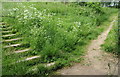
Oakham Nature Reserve, Mansfield, Notts.
A rudimentary ramp and some steps at the midpoint in a walk through the southern section of this “local nature reserve”. This LNR was created in 2005 to replace habitats lost through the construction of Oakham Business Park and it covers 6.3 hectares. Behind the photographer and a high fence is two-thirds of a former industrial mill pond (now a private fishing pond) that was bisected into one larger expanse of water and another smaller pond. This occurred following a decision by someone to create an embankment straight across the mill pond to carry a railway track from Reeds Mill(s) in the Bleak Hill area of the town to the area where Kingsmill Hospital is now situated.
Image: © David Hallam-Jones
Taken: 16 Jun 2013
0.09 miles
5
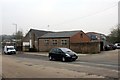
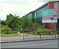
Industrial premises on Sheepbridge Lane
Image: © Graham Hogg
Taken: 31 Mar 2014
0.09 miles
6
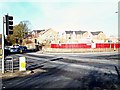
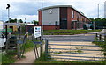
Sheepbridge Lane, Mansfield, Notts.
Some older maps indicate that this area was once given over to allotments. Another marks a pub on this corner. Now however, a new-build housing development is almost complete on a site currently known as "Heritage Park". The entrance to this new estate of 17 houses, on Quarry Lane - to the right - has been named Woodland Park View.
Image: © David Hallam-Jones
Taken: 19 Nov 2017
0.09 miles
7

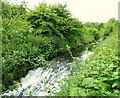
Quarry Lane Local Nature Reserve
Southern end of the Quarry Lane riverside walk
Image: © Antony Dixon
Taken: 24 Aug 2011
0.11 miles
8
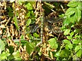
Dragonfly Resting
Photo taken by the path through the Oakham Local Nature Reserve. It is a southern hawker dragonfly (Aeshna cyanea). They are big - nearly 3 inches.
Image: © Antony Dixon
Taken: 23 Sep 2011
0.11 miles
9
Oakham Nature Reserve, Mansfield, Notts.
A weir on the River Maun at the mid-point in this northern section of particular local nature reserve. This LNR is one of nine in the Mansfield area. The mid-point of the overall route, i.e. where the path crosses Hamilton Way and the southern section begins (or ends), is accessed is 10 minutes walk away behind the photographer. The other end of this northern section, i.e. on Hermitage Lane, is 10 minutes walk ahead.
Image: © David Hallam-Jones
Taken: 16 Jun 2013
0.12 miles
10
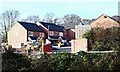
Woodland Park View, Mansfield, Notts.
This new-build development of 17 houses, seen from Quarry Lane Local Nature Reserve, is almost complete. It is being marketed commercially as "Heritage Park". The principal road into the estate has been named Woodland Park View. The entrance - ahead - is on Quarry Lane. In former times this area boasted allotments.
Image: © David Hallam-Jones
Taken: 19 Nov 2017
0.12 miles