IMAGES TAKEN NEAR TO
Bloomsbury Gardens, MANSFIELD, NG18 4XY
Introduction
This page details the photographs taken nearby to Bloomsbury Gardens, NG18 4XY by members of the Geograph project.
The Geograph project started in 2005 with the aim of publishing, organising and preserving representative images for every square kilometre of Great Britain, Ireland and the Isle of Man.

There are currently over 7.5m images from over14,400 individuals and you can help contribute to the project by visiting https://www.geograph.org.uk
Image Map
Images are licensed for reuse under creativecommons.org/licenses/by-sa/2.0
Notes
- Clicking on the map will re-center to the selected point.
- The higher the marker number, the further away the image location is from the centre of the postcode.
Image Listing (33 Images Found)
Images are licensed for reuse under creativecommons.org/licenses/by-sa/2.0
Image
Details
Distance
1
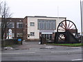
Mansfield - UDM offices at Berry Hill
The Union of Democratic Miners (UDM) was set up in 1985 following the 1984-85 miners strike. The pit winding wheel next to the office entrance on Berry Hill Lane has a plaque which lists the collieries within the Nottinghamshire area of the National Coal Board.
Image: © Dave Bevis
Taken: 14 Dec 2010
0.01 miles
2
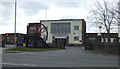
Union of Democratic Mineworkers - Nottingham Section
On Berry Hill Lane.
Image: © JThomas
Taken: 17 Mar 2014
0.01 miles
6
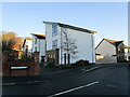
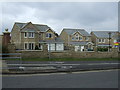
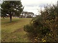
Berry Hill Lane Vicinity, Mansfield, Notts.
A new-ish housing development on the northern boundary of Berry Hill Park, with the edge of the athletics track in the foreground. The footpath in the centre connects Lichfield Lane with Blackscotch Lane on its eastern edge.
Image: © David Hallam-Jones
Taken: 16 Jul 2017
0.06 miles
7
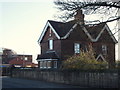
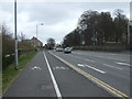
Berry Hill Lane, Mansfield, Notts.
A private house with a lodge-style appearance situated between a driveway entrance to the former Berry Hill Hall and "The Coal Industry Social Welfare Organisation" (CISWO) premises beyond it. Berry Hill Park is situated behind the rear boundary wall of this property and it can be accessed by on foot via a gate to the photographer's right, i.e. at the side of Berry Hill Hall.
Image: © David Hallam-Jones
Taken: 15 Jan 2016
0.08 miles
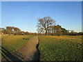
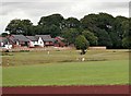
9
Berry Hill Park
Walking up from Black Scotch Plantation
Image: © norman griffin
Taken: 9 Feb 2018
0.09 miles
10
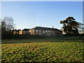
Former Berry Hill Hospital
Now apartments.
Image: © Jonathan Thacker
Taken: 13 Jan 2022
0.11 miles