IMAGES TAKEN NEAR TO
Norbury Drive, MANSFIELD, NG18 4HT
Introduction
This page details the photographs taken nearby to Norbury Drive, NG18 4HT by members of the Geograph project.
The Geograph project started in 2005 with the aim of publishing, organising and preserving representative images for every square kilometre of Great Britain, Ireland and the Isle of Man.

There are currently over 7.5m images from over14,400 individuals and you can help contribute to the project by visiting https://www.geograph.org.uk
Image Map
Images are licensed for reuse under creativecommons.org/licenses/by-sa/2.0
Notes
- Clicking on the map will re-center to the selected point.
- The higher the marker number, the further away the image location is from the centre of the postcode.
Image Listing (25 Images Found)
Images are licensed for reuse under creativecommons.org/licenses/by-sa/2.0
Image
Details
Distance
1
Jenny Beckett's Lane, Mansfield (2)
Looking towards Southwell Road West from the junction with Clifton Grove.
Image: © Richard Vince
Taken: 12 Dec 2020
0.08 miles
2
Jenny Beckett's Lane, Mansfield (1)
Looking towards Berry Hill Lane from the end of Clifton Grove.
Image: © Richard Vince
Taken: 12 Dec 2020
0.09 miles
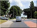
5
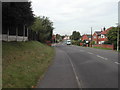
Jenny Beckett's Lane, Mansfield
near the junction of the Southwell Road
Image: © Tom Courtney
Taken: 9 Oct 2005
0.14 miles
6
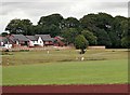
Berry Hill Lane Vicinity, Mansfield, Notts.
A new-ish housing development on the northern boundary of Berry Hill Park, with the edge of the athletics track in the foreground. The footpath in the centre connects Lichfield Lane with Blackscotch Lane on its eastern edge.
Image: © David Hallam-Jones
Taken: 16 Jul 2017
0.15 miles
9
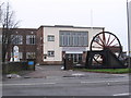
Mansfield - UDM offices at Berry Hill
The Union of Democratic Miners (UDM) was set up in 1985 following the 1984-85 miners strike. The pit winding wheel next to the office entrance on Berry Hill Lane has a plaque which lists the collieries within the Nottinghamshire area of the National Coal Board.
Image: © Dave Bevis
Taken: 14 Dec 2010
0.19 miles