IMAGES TAKEN NEAR TO
Jenny Beckett Lane, MANSFIELD, NG18 4HP
Introduction
This page details the photographs taken nearby to Jenny Beckett Lane, NG18 4HP by members of the Geograph project.
The Geograph project started in 2005 with the aim of publishing, organising and preserving representative images for every square kilometre of Great Britain, Ireland and the Isle of Man.

There are currently over 7.5m images from over14,400 individuals and you can help contribute to the project by visiting https://www.geograph.org.uk
Image Map
Images are licensed for reuse under creativecommons.org/licenses/by-sa/2.0
Notes
- Clicking on the map will re-center to the selected point.
- The higher the marker number, the further away the image location is from the centre of the postcode.
Image Listing (20 Images Found)
Images are licensed for reuse under creativecommons.org/licenses/by-sa/2.0
Image
Details
Distance
1
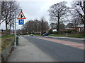
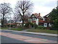
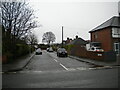
Southwell Road West (A6191)
Towards Mansfield town centre.
Image: © JThomas
Taken: 17 Mar 2014
0.10 miles
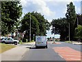
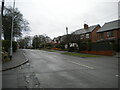
6
Jenny Beckett's Lane, Mansfield (2)
Looking towards Southwell Road West from the junction with Clifton Grove.
Image: © Richard Vince
Taken: 12 Dec 2020
0.11 miles
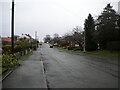
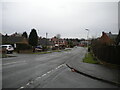
7
Jenny Beckett's Lane, Mansfield
near the junction of the Southwell Road
Image: © Tom Courtney
Taken: 9 Oct 2005
0.11 miles
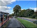
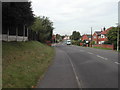
8
Jenny Beckett's Lane, Mansfield (1)
Looking towards Berry Hill Lane from the end of Clifton Grove.
Image: © Richard Vince
Taken: 12 Dec 2020
0.13 miles
9
Columbia Avenue, Mansfield
A residential cul de sac off Big Barn Lane.
Image: © Richard Vince
Taken: 12 Dec 2020
0.16 miles
10
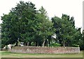
Charles Thompson's Grave, Berry Hill, Mansfield, Notts.
The plot of land - said to be the highest point above sea level in Mansfield - hosts the solitary grave of Charles Thompson, an C18th merchant and philanthropist, within an otherwise undeveloped open space. This is a view from Southwell Road West (the A6191). Thompson's grave lies deep beneath the ground surrounded by this stone wall. Although Charles Thompson, a successful cloth trader and local philanthropist (1714-1784), was born in Mansfield he spent much of his life outside of Nottinghamshire and the British Isles. Once, whilst in Lisbon, there was an earthquake and churches, amongst other buildings, tumbled and graves were upturned revealing bones and bodies. Upon his return to Mansfield, and as a result of this incident, Charles apparently decided that he would make arrangements for his body to be buried 18 feet down, so he could rest undisturbed by such occurrences. 33 years after his quake-proof burial here Mansfield, it seems, was struck by a "thoroughly authenticated earthquake of 4.2 on the Richter scale on 17 March 1816." 100-150 metres beyond the grave's circular boundary wall pedestrians find themselves on Berry Hill Lane.
Image: © David Hallam-Jones
Taken: 16 Jul 2017
0.16 miles