IMAGES TAKEN NEAR TO
Jersey Gardens, MANSFIELD, NG18 4GZ
Introduction
This page details the photographs taken nearby to Jersey Gardens, NG18 4GZ by members of the Geograph project.
The Geograph project started in 2005 with the aim of publishing, organising and preserving representative images for every square kilometre of Great Britain, Ireland and the Isle of Man.

There are currently over 7.5m images from over14,400 individuals and you can help contribute to the project by visiting https://www.geograph.org.uk
Image Map
Images are licensed for reuse under creativecommons.org/licenses/by-sa/2.0
Notes
- Clicking on the map will re-center to the selected point.
- The higher the marker number, the further away the image location is from the centre of the postcode.
Image Listing (24 Images Found)
Images are licensed for reuse under creativecommons.org/licenses/by-sa/2.0
Image
Details
Distance
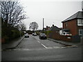
3
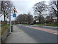
Southwell Road West (A6191)
Towards Mansfield town centre.
Image: © JThomas
Taken: 17 Mar 2014
0.05 miles
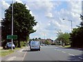
4
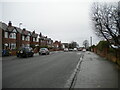
Big Barn Lane, Mansfield
Near its south end.
Image: © Richard Vince
Taken: 12 Dec 2020
0.08 miles
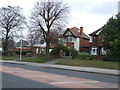
5
Columbia Avenue, Mansfield
A residential cul de sac off Big Barn Lane.
Image: © Richard Vince
Taken: 12 Dec 2020
0.08 miles
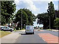
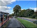
7

Cycle route off Big Barn Lane, Mansfield
Follows the course of the former Midland Railway line from Rolleston Junction to Mansfield.
Image: © Jonathan Thacker
Taken: 21 Jan 2022
0.13 miles
9
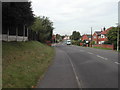
Jenny Beckett's Lane, Mansfield
near the junction of the Southwell Road
Image: © Tom Courtney
Taken: 9 Oct 2005
0.15 miles
10

Big Barn Lane, Methodist Church, Mansfield
Image: © Jonathan Thacker
Taken: 21 Jan 2022
0.17 miles