IMAGES TAKEN NEAR TO
Bramble Lane, MANSFIELD, NG18 3NR
Introduction
This page details the photographs taken nearby to Bramble Lane, NG18 3NR by members of the Geograph project.
The Geograph project started in 2005 with the aim of publishing, organising and preserving representative images for every square kilometre of Great Britain, Ireland and the Isle of Man.

There are currently over 7.5m images from over14,400 individuals and you can help contribute to the project by visiting https://www.geograph.org.uk
Image Map
Images are licensed for reuse under creativecommons.org/licenses/by-sa/2.0
Notes
- Clicking on the map will re-center to the selected point.
- The higher the marker number, the further away the image location is from the centre of the postcode.
Image Listing (13 Images Found)
Images are licensed for reuse under creativecommons.org/licenses/by-sa/2.0
Image
Details
Distance
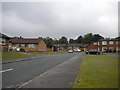
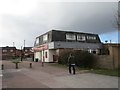
1
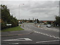
Junction of Oaktree Lane and Jubilee Way, Mansfield
At the traffic island, beyond the pelican crossing, Oak Tree Lane goes to the left and Jubilee Way South goes to the right.
Image: © Tom Courtney
Taken: 9 Oct 2005
0.03 miles
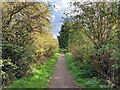
3
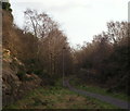
Bramble Lane Vicinity, Mansfield, Notts.
A stretch of The Mansfield Way (a medium distance trail) that was opened in 1987. This is a view towards Oak Field Lane. Bramble Lane, a residential street, is situated left of this cutting at the top of the embankment. This nature trail was created along what was formerly part of the route created for the Mansfield-Southwell Railway. A 2.5 mile long railway was built from Rolleston Junction on the Nottingham-Lincoln line to Southwell in 1847. In April 1871 the line was extended to Mansfield. This extension helped further development of the coalfield east of Mansfield, so much so that the increasing amount of coal-related traffic resulted in the whole line being doubled in the 1920s. The line closed to passengers in 1959.
Image: © David Hallam-Jones
Taken: 11 Jan 2015
0.12 miles
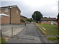
5
Thornton Close, Oak Tree estate
A residential cul de sac off Jubilee Way South.
Image: © Richard Vince
Taken: 14 Jun 2014
0.14 miles
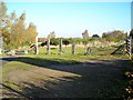
7
Bridleway off Jubilee Way South, Oak Tree estate
This public bridleway cuts across the estate in a manner that seems to indicate that it was here first. I am unsure quite how a horse would cope with negotiating the railings.
Image: © Richard Vince
Taken: 14 Jun 2014
0.17 miles
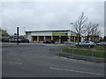
8
Western entrance to Oak Tree Heath
Oak Tree Heath is part of the Strawberry Hill Heaths Site of Special Scientific Interest. It consists of lowland heathland, now one of our most threatened and fragile habitats. One fifth of the world's lowland heath is in Britain, and this is one of Nottinghamshire's largest remaining areas, although it was once typical of the Sherwood Forest landscape.
Image: © Antony Dixon
Taken: 11 Nov 2012
0.18 miles
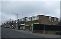
9
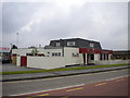
The Cuckoo Birch, Oak Tree estate
A rather oddly styled pub on Jubilee Way South.
Image: © Richard Vince
Taken: 14 Jun 2014
0.20 miles
10
The Cuck o B rch
Or, if all the letters were there, The Cuckoo Birch.
Image: © Jonathan Thacker
Taken: 8 Mar 2020
0.22 miles