IMAGES TAKEN NEAR TO
Lambley Avenue, MANSFIELD, NG18 3JR
Introduction
This page details the photographs taken nearby to Lambley Avenue, NG18 3JR by members of the Geograph project.
The Geograph project started in 2005 with the aim of publishing, organising and preserving representative images for every square kilometre of Great Britain, Ireland and the Isle of Man.

There are currently over 7.5m images from over14,400 individuals and you can help contribute to the project by visiting https://www.geograph.org.uk
Image Map
Images are licensed for reuse under creativecommons.org/licenses/by-sa/2.0
Notes
- Clicking on the map will re-center to the selected point.
- The higher the marker number, the further away the image location is from the centre of the postcode.
Image Listing (10 Images Found)
Images are licensed for reuse under creativecommons.org/licenses/by-sa/2.0
Image
Details
Distance
1

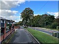
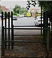
Cycle route off Big Barn Lane, Mansfield
Follows the course of the former Midland Railway line from Rolleston Junction to Mansfield.
Image: © Jonathan Thacker
Taken: 21 Jan 2022
0.12 miles
2

Big Barn Lane, Methodist Church, Mansfield
Image: © Jonathan Thacker
Taken: 21 Jan 2022
0.12 miles
3

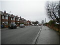
Houses on Big Barn Lane, Mansfield
A mixture of post war housing.
Image: © Jonathan Thacker
Taken: 21 Jan 2022
0.13 miles
4

Cycle route off Big Barn Lane, Mansfield
Follows the course of the former Midland Railway line from Mansfield to Rolleston Junction.
Image: © Jonathan Thacker
Taken: 21 Jan 2022
0.17 miles
5
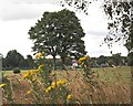
Racecourse Recreation Ground, Mansfield, Notts.
In Medieval times this area is said to have been part of the royal hunting domain of Sherwood Forest.
Image: © David Hallam-Jones
Taken: 16 Jul 2017
0.20 miles
6
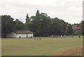
Racecourse Recreation Ground, Mansfield, Notts.
A recreation ground that has been developed on the site of a former racecourse. The houses in the background are in Maltby Road.
Image: © David Hallam-Jones
Taken: 16 Jul 2017
0.21 miles
7
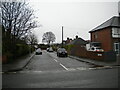
Big Barn Lane, Mansfield
Near its south end.
Image: © Richard Vince
Taken: 12 Dec 2020
0.21 miles
9
Racecourse Road, Mansfield, Notts.
A view from one of the Racecourse Recreation Ground exits. Southwell Road West (the A6191) lies 150 metres ahead.
Image: © David Hallam-Jones
Taken: 16 Jul 2017
0.23 miles
10
Columbia Avenue, Mansfield
A residential cul de sac off Big Barn Lane.
Image: © Richard Vince
Taken: 12 Dec 2020
0.23 miles