IMAGES TAKEN NEAR TO
Eakring Road, MANSFIELD, NG18 3EW
Introduction
This page details the photographs taken nearby to Eakring Road, NG18 3EW by members of the Geograph project.
The Geograph project started in 2005 with the aim of publishing, organising and preserving representative images for every square kilometre of Great Britain, Ireland and the Isle of Man.

There are currently over 7.5m images from over14,400 individuals and you can help contribute to the project by visiting https://www.geograph.org.uk
Image Map
Images are licensed for reuse under creativecommons.org/licenses/by-sa/2.0
Notes
- Clicking on the map will re-center to the selected point.
- The higher the marker number, the further away the image location is from the centre of the postcode.
Image Listing (9 Images Found)
Images are licensed for reuse under creativecommons.org/licenses/by-sa/2.0
Image
Details
Distance
1
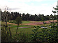
Sherwood Forest golf course
The Sherwood Forest golf course next to Eakring Road.
Image: © James Hill
Taken: 29 Aug 2007
0.06 miles
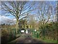
2
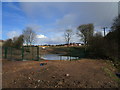
Pond and perimeter fence, Sherwood Forest Golf Club
The club house can be seen in the distance.
Image: © Jonathan Thacker
Taken: 8 Mar 2020
0.13 miles
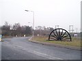
4
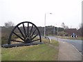
Colliery Headstocks Crown Farm Way, Clipstone
Crown Farm Way runs through the site of the former Crown Farm Colliery
Image: © Geoff Dunn
Taken: 3 Feb 2006
0.21 miles
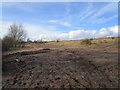
8
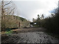
Golf course access
Sherwood Forest Golf Club.
Image: © Jonathan Thacker
Taken: 8 Mar 2020
0.24 miles
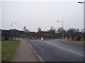
9
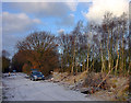
Eakring Road
To the east of Mansfield Rugby Club, at the end of the road adjacent to Sherwood Forest Golf Course. A light dusting of snow visible.
Image: © Andy Stephenson
Taken: 27 Dec 2005
0.25 miles