IMAGES TAKEN NEAR TO
Bath Lane, MANSFIELD, NG18 2ER
Introduction
This page details the photographs taken nearby to Bath Lane, NG18 2ER by members of the Geograph project.
The Geograph project started in 2005 with the aim of publishing, organising and preserving representative images for every square kilometre of Great Britain, Ireland and the Isle of Man.

There are currently over 7.5m images from over14,400 individuals and you can help contribute to the project by visiting https://www.geograph.org.uk
Image Map
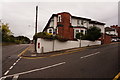
Images are licensed for reuse under creativecommons.org/licenses/by-sa/2.0
Notes
- Clicking on the map will re-center to the selected point.
- The higher the marker number, the further away the image location is from the centre of the postcode.
Image Listing (73 Images Found)
Images are licensed for reuse under creativecommons.org/licenses/by-sa/2.0
Image
Details
Distance
1
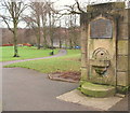
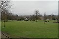
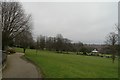
Carr Bank Park, Mansfield, Notts.
With the children's playground behind the photographer this footpath slopes away from the centre of the park towards Bath Lane, i.e the B6033. The disused drinking fountain commemorates the death of Mr Thomas Hartas, a former Chairman of the Water Committee, in 1937.
Image: © David Hallam-Jones
Taken: 7 Feb 2016
0.05 miles
2
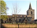
Saint Peter's Church, Mansfield
The parish church of St. Peter and St. Paul, Mansfield town centre. Constructed and modified during a period of several hundred years, parts of the building date from Norman times, mostly it is somewhat more recent. The two small narrow windows in the lower part of the church tower are a Norman feature, there is also a typically Norman rounded arch in the doorway (not visible here).
Image: © Peter Kochut
Taken: 11 Apr 2005
0.06 miles
3
Carr Bank Park, Mansfield, Notts.
One of several boule or petanque pistes are seen here overlooked by a pavilion. A gate into a fenced tennis court is also visible. It seems likely that the houses outside of the park's northern boundary are in Shirburn Avenue.
Image: © David Hallam-Jones
Taken: 7 Feb 2016
0.06 miles
4
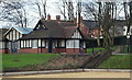
Carr Bank Park
The park in Mansfield, seen from the steps of Image
Image: © Bob Harvey
Taken: 10 Mar 2016
0.08 miles
5
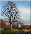
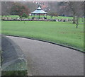
Carr Bank Park, Mansfield, Notts.
The bandstand and trees seen from near the children's playground.
Image: © David Hallam-Jones
Taken: 8 Jan 2015
0.09 miles
6
Carr Bank Park Bandstand, Mansfield, Notts.
The modern bandstand.
Image: © David Hallam-Jones
Taken: 8 Jan 2015
0.09 miles
7
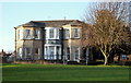
Mansfield Manor Hotel, Mansfield, Notts.
The hotel's front elevation. Houses to the side of it mark the location of Windmill Lane. The hotel (the former family home of the Stantons, previously known as Carr Bank House) is situated on the western boundary of this public park.
Image: © David Hallam-Jones
Taken: 8 Jan 2015
0.11 miles
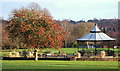
8
Carr Bank Park Bandstand, Mansfield, Notts.
The C21st bandstand seen from the front of The Mansfield Manor Hotel (formerly Carr Bank House). Houses on Kingston Street and Gladstone Road form a backdrop.
Image: © David Hallam-Jones
Taken: 8 Jan 2015
0.12 miles
9
Carr Bank Park
Once the parkland of the house, this is now a public park for the people of Mansfield, and a very good one too
Image: © Bob Harvey
Taken: 10 Mar 2016
0.12 miles