IMAGES TAKEN NEAR TO
Lochbuie Court, MANSFIELD, NG18 2BR
Introduction
This page details the photographs taken nearby to Lochbuie Court, NG18 2BR by members of the Geograph project.
The Geograph project started in 2005 with the aim of publishing, organising and preserving representative images for every square kilometre of Great Britain, Ireland and the Isle of Man.

There are currently over 7.5m images from over14,400 individuals and you can help contribute to the project by visiting https://www.geograph.org.uk
Image Map
Images are licensed for reuse under creativecommons.org/licenses/by-sa/2.0
Notes
- Clicking on the map will re-center to the selected point.
- The higher the marker number, the further away the image location is from the centre of the postcode.
Image Listing (43 Images Found)
Images are licensed for reuse under creativecommons.org/licenses/by-sa/2.0
Image
Details
Distance
1
Windmill Lane, Mansfield, Notts.
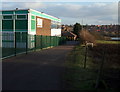
A right-hand glance when standing in front of the entrance gates that provide access into the south-west corner of the Brunt's Academy provides a view of this building, "The Mansfield Community Performance Centre". Since this building is on the Brunt's Academy site perhaps it is safe to assume that the building was (or is) a jointly funded venture? The Brunts Academy is a large secondary school that specialises in the Performing Arts. Brunts has been a Grammar School and a Technical School in the past and it traces its foundation to a bequest by Samuel Brunts in 1709. This was the year that Samuel Brunts left a bequest that was used by an Elementary School to assist local children "to learn an honest trade". The Brunts School became The Brunts Academy on 1st January 2012.
Image: © David Hallam-Jones
Taken: 8 Jan 2015
0.11 miles
2
Off Windmill Lane, Mansfield, Notts.
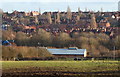
A view from near the closed end of this cul-de-sac, across a field that appears to be used for grazing horses. Near to the photographer's left is an entrance into the south-west corner of the Brunts Academy. The long, low building at the foot of this field is also part of the school, served by an extremely long drive that branches off Bath Lane. This is a large secondary school that specialises in the Performing Arts. Brunts has been a Grammar School and a Technical School in the past and it traces its foundation to a bequest by Samuel Brunts in 1709. This was the year that Samuel Brunts left a bequest that was used by an Elementary School to assist local children "to learn an honest trade". The Brunts School became The Brunts Academy on 1st January 2012.
Image: © David Hallam-Jones
Taken: 8 Jan 2015
0.12 miles
3
Windmill Lane, Mansfield, Notts.
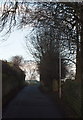
These are the final few metres of a quiet cul-de-sac. Behind the wall on the right are fields being used for horse-grazing, whilst a range of disused greenhouses occupy the land behind the left-hand wall. Up ahead there is a performing arts block - part of the Brunt's Academy - behind a security fence and entrance gates. The Mansfield Manor Hotel (formerly Carr Bank House) and Carr Bank Park lie behind the photographer.
Image: © David Hallam-Jones
Taken: 8 Jan 2015
0.13 miles
4
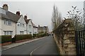
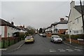
Edgar Avenue
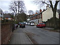
Heading east off Woodhouse Road.
Image: © JThomas
Taken: 16 Mar 2014
0.15 miles
7
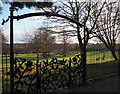
Rose Garden, Carr Bank Park, Mansfield, Notts.
A view of the largest area of the park through a pair of ornate gates on the southern border of the rose garden. This rose garden, the only formal rose garden in any of Mansfield's parks, is situated in the north-west corner of the park.
Image: © David Hallam-Jones
Taken: 8 Jan 2015
0.17 miles
8
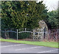
Grotto, Carr Bank Park, Mansfield, Notts.
Beyond the eastern boundary fence of this car park (off Windmill Lane), shared by The Mansfield Manor Hotel and Carr Bank Park, is this Grade II-listed early-C19th garden grotto that was restored in the late C20th. It is of limestone rubble stabilised with cement and partly covered with earth. It is in the form of a curved tunnel with this conical shaped entrance on its west side. Its east entrance/exit, situated in the formal rose garden (now part of the park), takes the form of a segmental arch. The structure is thought to have been built as part of the house's gardens that were created on three sides of it, excluding of course the side occupied by the converted stable block parallel with Windmill Lane.
Image: © David Hallam-Jones
Taken: 8 Jan 2015
0.18 miles
9
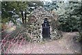
Garden Grotto
Georgian era romantic folly in the form of a Grotto or Hermit's cell, restored in the early 20th century and fitted with 21st century gate matching the park ironwork. Once park of the garden at Carr Bank House, this is now in the public park of the same name. it is a grade II listed building in its own right (https://www.historicengland.org.uk/listing/the-list/list-entry/1287951 )
Image: © Bob Harvey
Taken: 10 Mar 2016
0.18 miles
10
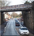
Leeming Lane South, Mansfield Woodhouse, Notts.
Leeming Lane South, i.e. the A60, is visible ahead in the Market Warsop direction. This bridge carries trains between Mansfield and Mansfield Woodhouse stations. The section of the A60 on this side of the bridge is Mansfield Road.
Image: © David Hallam-Jones
Taken: 23 Jan 2016
0.18 miles