IMAGES TAKEN NEAR TO
Woodhouse Road, MANSFIELD, NG18 2AB
Introduction
This page details the photographs taken nearby to Woodhouse Road, NG18 2AB by members of the Geograph project.
The Geograph project started in 2005 with the aim of publishing, organising and preserving representative images for every square kilometre of Great Britain, Ireland and the Isle of Man.

There are currently over 7.5m images from over14,400 individuals and you can help contribute to the project by visiting https://www.geograph.org.uk
Image Map
Images are licensed for reuse under creativecommons.org/licenses/by-sa/2.0
Notes
- Clicking on the map will re-center to the selected point.
- The higher the marker number, the further away the image location is from the centre of the postcode.
Image Listing (65 Images Found)
Images are licensed for reuse under creativecommons.org/licenses/by-sa/2.0
Image
Details
Distance
2
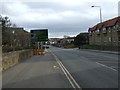
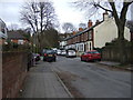
Woodhouse Road (A60), Mansfield
Heading south.
Image: © JThomas
Taken: 16 Mar 2014
0.09 miles
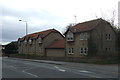
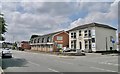
3
Mansfield - Eden Court on Crow Hill Drive
Image: © Dave Bevis
Taken: 17 Sep 2013
0.09 miles
4
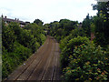
Robin Hood Line, Mansfield
The Robin Hood Line as it passes beneath the bridge next to Carr Bank Park in Mansfield.
Image: © James Hill
Taken: 2 Jul 2007
0.14 miles
5
Edgar Avenue
Heading east off Woodhouse Road.
Image: © JThomas
Taken: 16 Mar 2014
0.14 miles
6
Nursery Street Bridge, Mansfield, Notts.
With Nursery Street - and even further back, the town centre - behind the photographer this is a view of the railway bridge (Ref No.PBS3-34) with the main entrance to Carr Bank Park immediately ahead. Railway traffic passing beneath the bridge is generally en-route for Mansfield or Mansfield Woodhouse. Only Windmill Lane and The Park (a road name) are served by the road ahead, apart from those drivers intending to park in the combined car park that serves The Carr Bank Hotel and Carr Bank Park.
Image: © David Hallam-Jones
Taken: 8 Jan 2015
0.15 miles
8
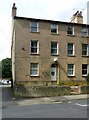
5 Terrace Road, Mansfield
The end house of the terrace. See http://www.geograph.org.uk/photo/6259602 for location.
Image: © Alan Murray-Rust
Taken: 21 Aug 2019
0.17 miles
9
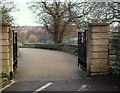
Carr Bank Park, Mansfield, Notts.
The main pedestrian entrance into this park. Vehicular access and parking is to be found a further 200-300 yards along Windmill Lane, to the left of these gates.
Image: © David Hallam-Jones
Taken: 8 Jan 2015
0.17 miles
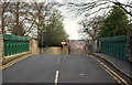
10
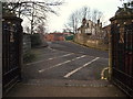
Nursery Street Bridge, Windmill Lane, Mansfield, Notts
Nursery Street itself lies 5-6 metres ahead, on the other side of this bridge. This is a view of railway bridge No.PBS3-34 from Carr Bank Park's main entrance. Railway traffic passing beneath the bridge is generally en-route for either Mansfield or Mansfield Woodhouse.
Image: © David Hallam-Jones
Taken: 8 Jan 2015
0.17 miles