IMAGES TAKEN NEAR TO
Stockwell Gateway, Stockwell Gate, NG18 1LH
Introduction
This page details the photographs taken nearby to Stockwell Gateway, Stockwell Gate, NG18 1LH by members of the Geograph project.
The Geograph project started in 2005 with the aim of publishing, organising and preserving representative images for every square kilometre of Great Britain, Ireland and the Isle of Man.

There are currently over 7.5m images from over14,400 individuals and you can help contribute to the project by visiting https://www.geograph.org.uk
Image Map
Images are licensed for reuse under creativecommons.org/licenses/by-sa/2.0
Notes
- Clicking on the map will re-center to the selected point.
- The higher the marker number, the further away the image location is from the centre of the postcode.
Image Listing (271 Images Found)
Images are licensed for reuse under creativecommons.org/licenses/by-sa/2.0
Image
Details
Distance
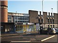
4
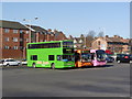
Colour coordinates?
Colourful buses at Mansfield Bus Station.
Image: © Alan Murray-Rust
Taken: 27 Mar 2012
0.01 miles
6
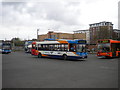
Buses in Mansfield bus station
A 6 to Bull Farm passes more buses sitting between duties in the parking area of the soon to be replaced Mansfield bus station. The arrival and departure stands are located behind the photographer.
Image: © Richard Vince
Taken: 14 Apr 2012
0.02 miles
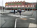
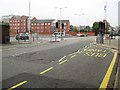
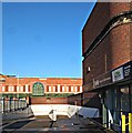
7
Portland Street, Mansfield, Notts.
This former bus station opened in November 1977 and closed in March 2013 following the opening of a new bus station on Quaker Way. The bus manoeuvring area is currently in use as a public car park.
Image: © David Hallam-Jones
Taken: 20 Jan 2017
0.02 miles
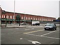
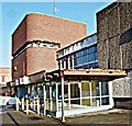
8
Former Bus Station, Mansfield, Notts.
The former bus station's Travel Centre, with one of the town's multi-storey car parks behind it. The original bus station opened in 1977 and it was closed in 2013 when the new bus station opened in Quaker Way. The bus manoeuvring area is currently being used as a public car park.
Image: © David Hallam-Jones
Taken: 20 Jan 2017
0.02 miles
9
Former Bus Station, Mansfield, Notts.
The defunct Travel Centre that was part of the former bus station (1977-2013). In the background is the Rosemary (shopping) Centre, Walkden Street that is housed on the site of "Lawn Mills". This mill's function was to prepare cotton that was sent away for weaving in the damper atmosphere of Lancashire. The mill was owned by the Cash family.
Image: © David Hallam-Jones
Taken: 20 Jan 2017
0.02 miles