IMAGES TAKEN NEAR TO
Acorn Business Park, Commercial Gate, MANSFIELD, NG18 1EX
Introduction
This page details the photographs taken nearby to Acorn Business Park, Commercial Gate, NG18 1EX by members of the Geograph project.
The Geograph project started in 2005 with the aim of publishing, organising and preserving representative images for every square kilometre of Great Britain, Ireland and the Isle of Man.

There are currently over 7.5m images from over14,400 individuals and you can help contribute to the project by visiting https://www.geograph.org.uk
Image Map
Images are licensed for reuse under creativecommons.org/licenses/by-sa/2.0
Notes
- Clicking on the map will re-center to the selected point.
- The higher the marker number, the further away the image location is from the centre of the postcode.
Image Listing (158 Images Found)
Images are licensed for reuse under creativecommons.org/licenses/by-sa/2.0
Image
Details
Distance
1
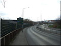
St Peter's Way (A6009)
Ring road heading clockwise around Mansfield.
Image: © JThomas
Taken: 16 Mar 2014
0.04 miles
3
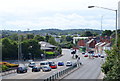
Mansfield, Notts.
A view of Nottingham Road (the A60) looking in the Ravenshead, Newstead and Nottingham direction as seen from a new-ish footbridge that crosses over Portland Street.
Image: © David Hallam-Jones
Taken: 13 Sep 2013
0.06 miles
4
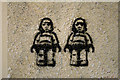
Lego Stormtroopers
Stencilled graffiti in the subway between Commercial Gate and St. Peter's Way.
A passer-by told me there was a spate of these sprayed around the Mansfield subways.
Image: © David Lally
Taken: 22 Mar 2010
0.08 miles
5
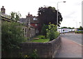
Mansfield, Notts (Portland Street)
A view of Portland Street (formerly Bull’s Head Lane) looking towards its junction with Nottingham Road. On the left are the "additional six" almshouses built in 1844 and funded by the Elizabeth Heath Charity. Although this row of cottages "for ancient ladies" was in use until the Winter of 2011/12 they are now empty and boarded up. The original single-bedroomed almshouses – twelve in number – are situated on Nottingham Road and are still inhabited. Elizabeth Heath (1617-93), a Mansfield resident and a Quaker, endowed these almshouses for women born in Mansfield or having lived in Mansfield for a substantial part of their lives and with limited assets - criteria that remain in use today. The allocation of residents i.e. "six Quakers and six church members of the established church" presumably demonstrated a wish to avoid clashing with the Anglican authorities given that Quakers were frequently shunned by most other authorities at this time?
Image: © David Hallam-Jones
Taken: 15 Jul 2012
0.08 miles
6
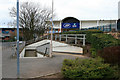
Entry to subway
On St. Peter's Way.
The other end emerges onto Commercial Gate. In the background is the Mansfield Town football ground (left) and the Boot's store on the St. Peter's Retail Park (centre and right).
Image: © David Lally
Taken: 22 Mar 2010
0.08 miles
7
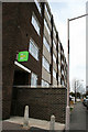
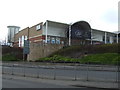
Mansfield Job Centre Plus
On Commercial Gate.
Image: © David Lally
Taken: 22 Mar 2010
0.08 miles
8
Portland Street, Mansfield, Notts.
The 280-tonne futuristic Gateway Bridge was put into place in the autumn of 2001. The footbridge, that cost £600,000, stretches 40 metres over this inner ring road and acts as the centrepiece of a major environmental improvement project that saw the transformation of the previously rundown Belvedere Street, Portland Street and Stockwell Gate area. Prior to the opening of the bridge, pedestrians and cyclists had to negotiate a multi-lane carriageway to access the “Portland Sidings Retail Park” and the football ground. The footbridge links the Portland Sidings shopping area on the left with the town centre and St Peter’s Retail Park on the right.
Image: © David Hallam-Jones
Taken: 17 Apr 2016
0.08 miles
9
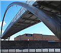
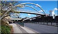
Portland Street, Mansfield, Notts.
The 280-tonne futuristic Gateway Bridge was installed place in the autumn of 2001. The £600,000 footbridge stretches 40 metres over this inner ring road and acts as the centrepiece of a major environmental improvement project that saw the transformation of the previously rundown Belvedere Street, Portland Street and Stockwell Gate area. Prior to the opening of the bridge, pedestrians and cyclists had to negotiate a six-lane carriageway to get access to the “Portland Sidings Retail Park” and the football ground. The footbridge links the Portland Sidings shopping area behind the photographer with the town centre and St Peter’s Retail Park ahead.
Image: © David Hallam-Jones
Taken: 17 Apr 2016
0.09 miles
10
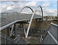
Footbridge to Shops
Close to Mansfield railway station, the pedestrian bridge over the inner ring road. It links the old town centre with the new shopping area next to the football ground.
Image: © Peter Kochut
Taken: 26 May 2005
0.10 miles