IMAGES TAKEN NEAR TO
Canal Street, NOTTINGHAM, NG1 7HG
Introduction
This page details the photographs taken nearby to Canal Street, NG1 7HG by members of the Geograph project.
The Geograph project started in 2005 with the aim of publishing, organising and preserving representative images for every square kilometre of Great Britain, Ireland and the Isle of Man.

There are currently over 7.5m images from over14,400 individuals and you can help contribute to the project by visiting https://www.geograph.org.uk
Image Map
Images are licensed for reuse under creativecommons.org/licenses/by-sa/2.0
Notes
- Clicking on the map will re-center to the selected point.
- The higher the marker number, the further away the image location is from the centre of the postcode.
Image Listing (1341 Images Found)
Images are licensed for reuse under creativecommons.org/licenses/by-sa/2.0
Image
Details
Distance
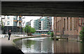
1
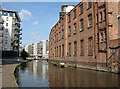
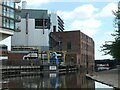
Nottingham Canal: where trains once crossed
Until the 1960s, trains from London Road High Level crossed the canal on a skew bridge just beyond the warehouse on the right, before crossing Narrow Marsh on brick arches on their way to Weekday Cross Junction (now the site of the Nottingham Contemporary gallery) and Nottingham Victoria. Everything railway-related has disappeared here, but a small stretch of the arches survives just north-west of here between Maltmill Lane and Popham Street - see Image Alan Murray-Rust's Image] shows this area in January 2008, when the flats straight ahead were being built.
Image: © John Sutton
Taken: 21 May 2011
0.01 miles
2
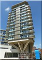
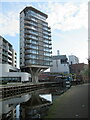
Nottingham One Tower
Comprising a mixture of 1- and 2-bedroom apartments.
Image: © Alan Murray-Rust
Taken: 26 May 2017
0.01 miles
3
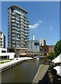
Nottingham Canal with Nottingham one tower
Taken from the (relatively) recently opened footbridge.
Image: © Alan Murray-Rust
Taken: 26 May 2017
0.01 miles
4
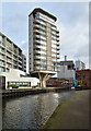
Nottingham One seen from The Nottingham Canal, Nottingham
Image: © habiloid
Taken: 17 Feb 2023
0.01 miles
5
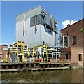
Enviroenergy power station
Originally built as a coal fired power station for the Boots Company factories in the area, when the company moved away it was taken over by Nottingham City Council. It was combined with the new Eastcroft incinerator http://www.geograph.org.uk/photo/5429878 continuing to generate electricity but also providing district heating over wide areas of the city centre and neighbouring residential areas.
Image: © Alan Murray-Rust
Taken: 26 May 2017
0.02 miles
6
Danger! Pump intake on the Nottingham Canal
The site of a former canal basin at Irongate Wharf.
Image: © Christine Johnstone
Taken: 5 May 2022
0.02 miles
7
Nottingham Canal-side Apartments
The Nottingham Canal is a canal in the English counties of Nottinghamshire and Derbyshire. As built, it comprised a 14.7-mile long main line between the River Trent just downstream of Trent Bridge in Nottingham and Langley Mill in Derbyshire
Image: © Roy Hughes
Taken: 16 Apr 2022
0.02 miles
8
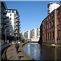
Along the towpath
Looking along the canal towards the city centre on a bright May morning. Image] shows this area in 2011, before the Nottingham One flats (in the centre) were completed.
Image: © John Sutton
Taken: 3 May 2016
0.02 miles
9
Nottingham Canal from under London Road bridge
There has been an enormous amount of new building here in recent years. Ahead there were once brick arches to the left and a bridge over the canal, carrying the Great Northern Railway at roof level through Sneinton from Trent Lane Junction to Nottingham Victoria via London Road High Level Station and Weekday Cross Junction (now the site of the Nottingham Contemporary art gallery). It is hard now for those who do not remember it to envisage how much railway infrastructure has been swept away.
Image: © John Sutton
Taken: 31 May 2010
0.02 miles
10

Tall buildings by the Nottingham Canal
A view from the terrace round the Jurys Inn hotel. This is where trains from Grantham once crossed the canal on their way to Weekday Cross Junction and Nottingham Victoria Station. The sun had yet to break through on what proved to be yet another hot, sunny day in July 2018.
Image: © John Sutton
Taken: 23 Jul 2018
0.02 miles