IMAGES TAKEN NEAR TO
Canal Street, NOTTINGHAM, NG1 7HB
Introduction
This page details the photographs taken nearby to Canal Street, NG1 7HB by members of the Geograph project.
The Geograph project started in 2005 with the aim of publishing, organising and preserving representative images for every square kilometre of Great Britain, Ireland and the Isle of Man.

There are currently over 7.5m images from over14,400 individuals and you can help contribute to the project by visiting https://www.geograph.org.uk
Image Map
Images are licensed for reuse under creativecommons.org/licenses/by-sa/2.0
Notes
- Clicking on the map will re-center to the selected point.
- The higher the marker number, the further away the image location is from the centre of the postcode.
Image Listing (1768 Images Found)
Images are licensed for reuse under creativecommons.org/licenses/by-sa/2.0
Image
Details
Distance
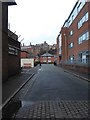
1
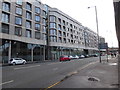
A stroll round Nottingham City Centre (11)
Looking west-southwest in Canal Street
Image: © Basher Eyre
Taken: 2 Dec 2018
0.02 miles
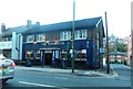
4
A stroll round Nottingham City Centre (16)
Nottingham Local News, 121 Canal Street
Image: © Basher Eyre
Taken: 2 Dec 2018
0.02 miles
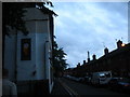
5
A stroll round Nottingham City Centre (17)
Looking from Canal Street into Shortwood Close
Image: © Basher Eyre
Taken: 2 Dec 2018
0.03 miles
6
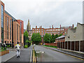
Along Rancliffe Street
Rancliffe Street is new, replacing Maltmill Lane and Popham Street, whose site is now covered by the new Nottingham College building, on the left. This is a view from the Canal Street end towards Cliff Road and, on top of the cliff, the Lace Market.
Image: © John Sutton
Taken: 21 May 2021
0.03 miles
7
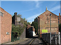
Great Northern Railway arches, Popham Street
From 1900, when services were transferred from London Road to the new Victoria Station, Grantham line trains snaked above Sneinton on a series of brick arches and bridges from Weekday Cross Junction – now the site of the Nottingham Contemporary art gallery – to London Road and Trent Lane Junction. Apart from the bridge abutments either side of the canal east of London Road http://www.geograph.org.uk/photo/1891197 , the only remains of this line are a set of blue-brick arches between Maltmill Lane and Popham Street. This line was last used, for freight traffic, in 1974 and all other traces of it have now disappeared. High Pavement Unitarian Chapel - now a bar - is behind the Cornish Engineering factory on the right.
For the other end of what remains, see Image
Image: © John Sutton
Taken: 27 Aug 2010
0.03 miles
8
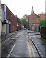
A rainy May evening in Popham Street
For more about the remains of the Great Northern Railway arches to the left of the oncoming car, see Image
Image: © John Sutton
Taken: 16 May 2013
0.04 miles
9
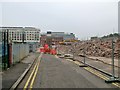
Demolition, Popham Street
Industrial buildings and the last remaining Great Northern Railway arches, between Popham Street and Maltmill Lane, disappeared in September 2014. Compare this picture with Image], and for an idea of the railway arches, and some railway history, see Image] and Image
Image: © John Sutton
Taken: 18 Sep 2014
0.04 miles
10
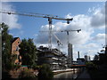
New Flats Under Construction on the Nottingham canal (1)
Image: © Oxymoron
Taken: 3 Sep 2008
0.04 miles